A working professional who love stravelling. Railfanning is a hobby and so is travelling. India is vast enough to be explored through travelling and all other countries will flal behind if tourism is exploted to fullest potential here
Winter season. The mountains covered with the snow. White background, freezing temperatures, layers of jackets , playing with the snow , snow burns and various activities are an experience to remember . Google maps, insta photos , social media become the major source of information of popular destinations , while bus, trains, personal vehicles become the source of travel . Solo tours, family tours , friend tours, group trips , form the companion for travel
The same winter season , for the birds , is a period to escape the harsh chillness of these mountains . It is the nature that guide them , and the presence of food that is vital. The only way for them to travel is depending on their own body fat , wings and their own group form the companions for travel
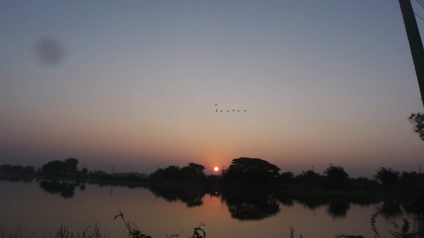
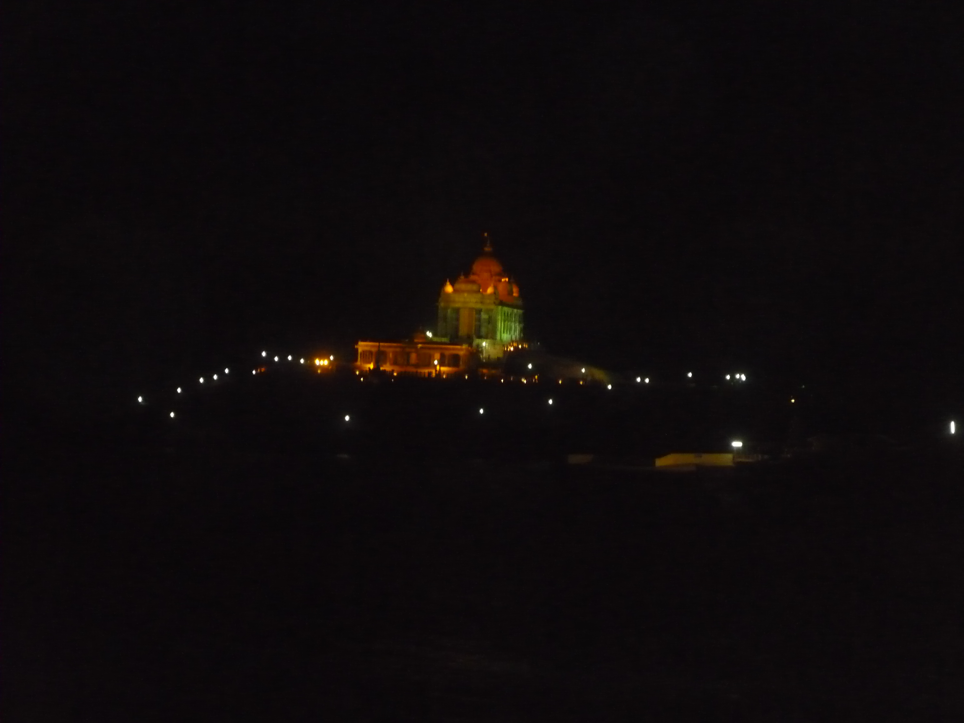
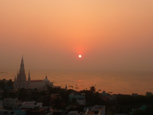
Sunrise at Magadikere
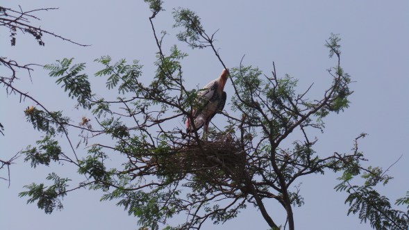
Towns that would normally form part of a highway passing through , would suddenly spring into life on arrivals of such winged beauties . Quaint and tiny these towns would have escaped the notice on the highway atlas , or even when passing through , or may be a silent on the road bus stop , in case of a bus journey . But for these winged visitors, these towns are the residence, with in-house accommodation , play areas , chatting points, growing points , till the end of the winter season
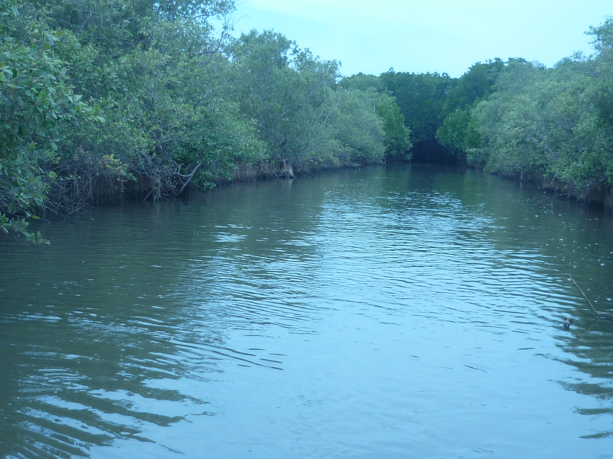
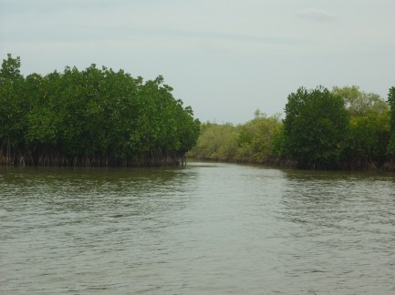
One such town, on the Gadag- Laxmeshwar highway in Karnataka , is Magadikere . The non descript town is a very small town on the highway , as a NWKRTC bus stops by to pick up the few passengers from the highway . A lake stands few metres away from the highway , just slightly away from the dust and the pollution of the highway and its vehicles
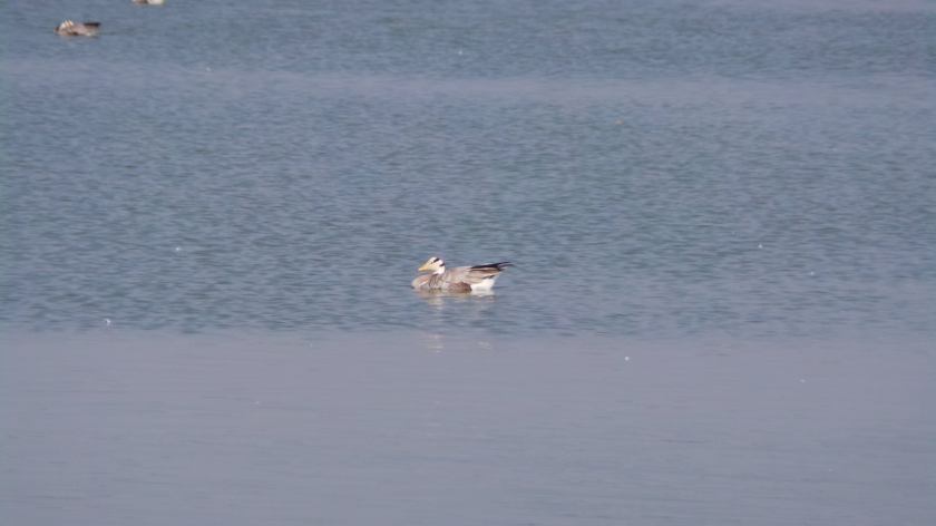
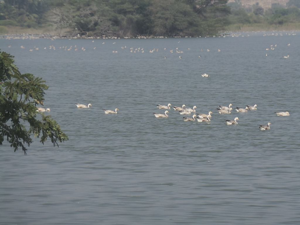
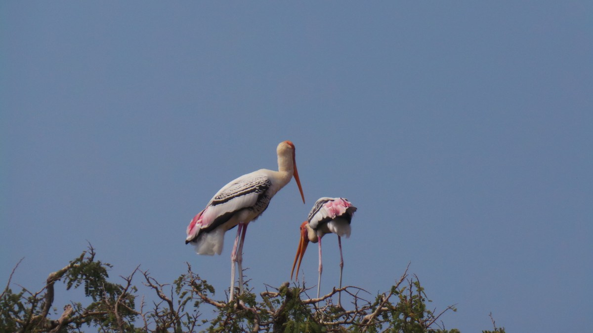
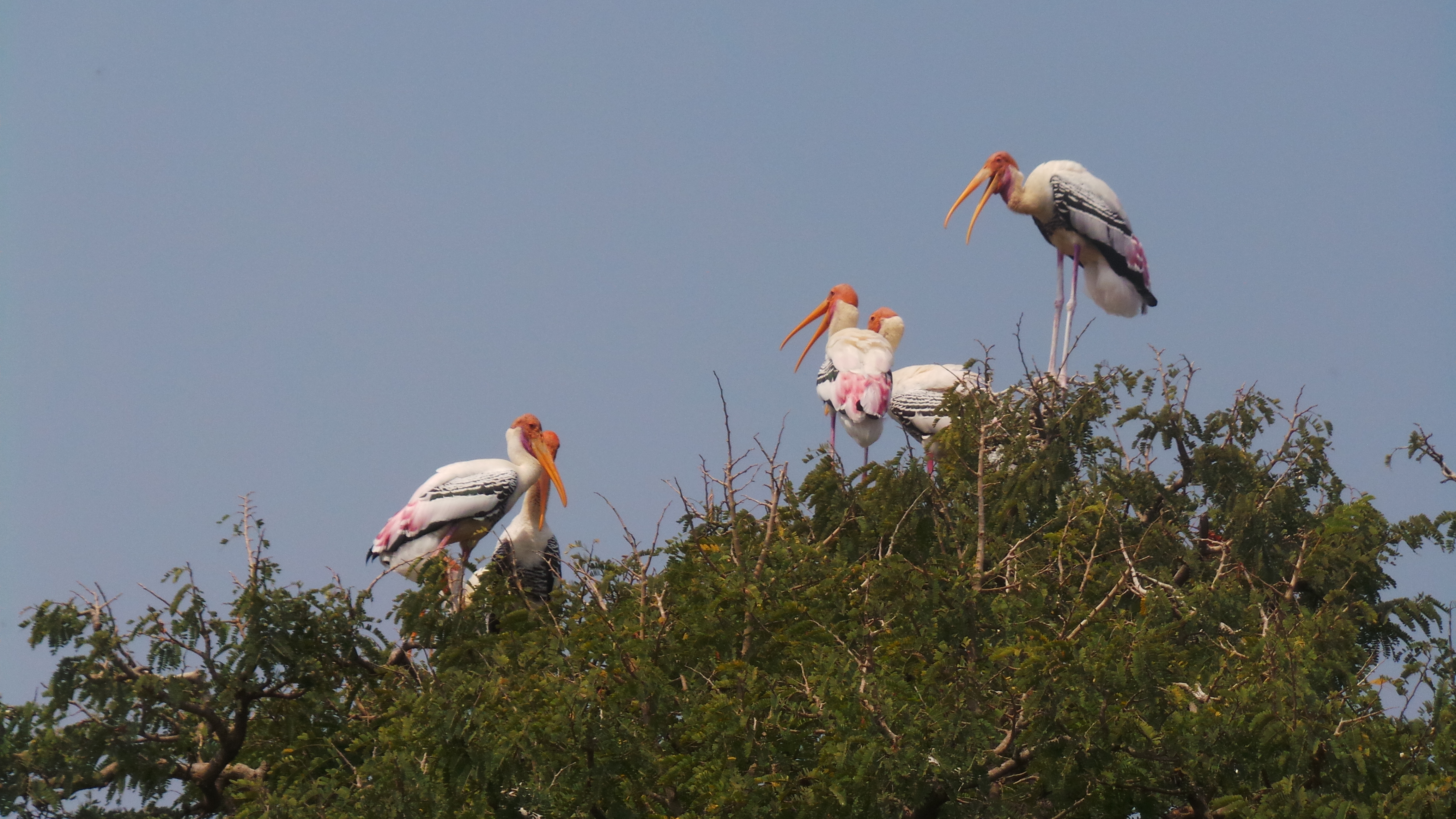
Bar headed geese
Every year , between November to March , this lake forms the home to the bird , that has earned the record as on of the world’s “highest fliers” . Tagged records , indicate that these birds , that have nesting records only at Ladakh in India , nests majorly in the cold regions of the Tibet, Mongolia, Kazhaksthan and Russia . These birds , fly across the Himalayan mountains , and burn their cholesterol weight in the process, as they fly past these mountain region in the “V” formation . The recorded flying height of 29000 feet , earned them as one of the highest flier tag These are the “Bar – headed” Geese , the name that they have received , because of the formation of 2 lines across their foreheads
Magadikere , in the deccan plateau of peninsular India , is one such location , chosen by these birds as their winter location . The groundnut fields in the nearby villages of this lake, form the major part of diet for these birds . The lake forms a safe location , the water is a refreshing coolant , and the trees a safe nesting location . The forest office located close, provides a feel of comfortable security for these birds
Leaving for breakfast
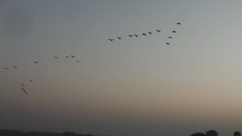
An early morning visit on Christmas , saw us spotting the birds from far against the rising sun , the birds having exiting the lake around 6AM. The leader just gave out a quack and behind them was the group following their leader . One, two, three , the groups just went off for their breakfast . Could just make out the shiloutte of these birds , as the morning sun was not very clear . The main lake wasn’t yet opened, it would be opened around 8AM , informed the security at the lake
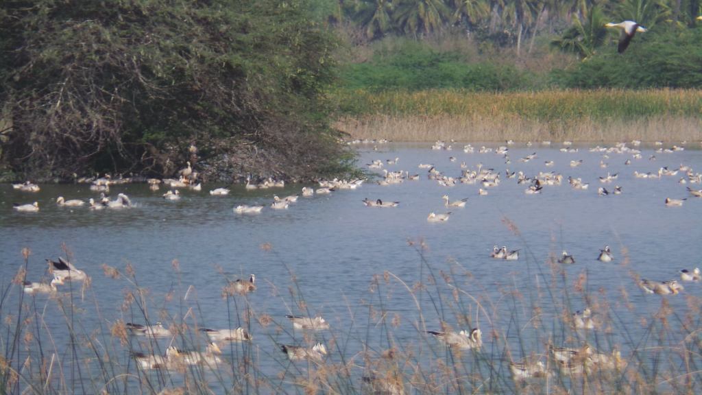
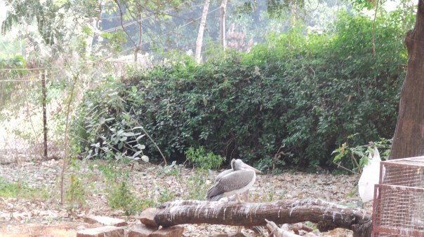
The December afternoon sun on the Christmas day , is slightly harsh and pretty dry , as we enter into the lake post our lunch session . A pied kingfisher looks at us from above the electric wire , welcoming us to the lake . The local buffaloes beat the harsh winter soaking in the lake waters at the entrance , as group of washer women go about on their afternoon chores . The lake was filled with white particles across , glittering in the afternoon sun , which could be mistaken for the foam of the clothes . Closer examination revealed that they were our guests . whom we had missed in the morning .
The birds that had left for the morning breakfast were now back . The lake was filled to the brim , by these winter visitors, as we made our way to the forest office and the watch tower . They had found a way to beat the winter sun , by staying in the cool waters . The sounds of the quacks filled the air , echoing across the lake . Groups & groups of these birds stayed thorugh the lake , swimming and chatting
Walked around the lake , towards the forest office and the watch tower. The sounds of the regular birds like Mynah, parakeets , wagtails , swallows, went unheard in the din of the bar headed geese .
Group of localites had made their way to the lake , to spend the winter afternoon, along with few bird watching groups . The local children hadn’t yet got exposed much to visitors and were surprised to see the binoculars in our hand . Mistaking it to be a camera , we were asked to take snaps, before we explained to them that it was only for viewing and not for capturing . Seeing the bar headed at close range through it gave them a different sort of excitement
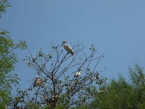
The forest officers had set of binoculars for the spotting of these birds , which they had rented to us. The board next to the forest office indicated the comparision height of various birds , along with the flight . Average height of the flight was mentioned in the 4th position , with the bar headed geese occupying the 3rd at around 29000 feet .
The steep flight of steps led us to the top of the watch tower and the site was a behold to watch. Each and every inch, corner space , island shores , tree shades were filled up with the line up of these birds , enjoying their vacation. The birds would again leave the cool waters by around 4PM for their evening snack, returning back around dusk for their sleep .
The forest department book gave an estimate of 6000-7000 for tat day . The initial starting days of the season started with about 600 birds , and then went down to 300, before again building up . The birds came to explore the place , found it safe and then went to get their families, was the prompt reply. Though they come every year , safety is first for them and they do not settle completely unless they find the place safe .
A small set of demoiselle crane was in the list maintained by the guard , but the same could not be found . It came 2 days back , but it could not stand the crowd of these geese . So it has shifted to a new residence about 5 kms away. Thought of visiting the same, but the security guard stopped us . Not much of use , he felt, for it would have changed location due to non availability of food. It hasnt settled yet .
A lone bar headed geese for standing near the forest office . The bird was feeling sick , and it headed out of the lake to the forest office , where it felt it could be safe . The birds rely on humans , when it feels insecure . But shy that it was, the presence of new humans around , made it move to a corner and hide . It relies only on the forest guard who feed it , not visitors . Atleast it still trusts humans
Migration , is a yearly phenomenon , and how they manage to do that every year , finding their way , is seriously a fascinating fact . No googlemaps , no landmarks , fear of predators , no transport, no tickets and above all no passport and no office leave requests . Staying with nature , living on their natural body and foods , and travel becomes a pretty easy affair . The wing feathers do have their wear and tear , and they wither and moult again , well in time to gain the strength for them to undertake the long journey again in March , when the deccan plateau will perspire in the summer heat .
Location : Magadikere – Located about 25 kms South of Gadag on the Gadag Laxmeshwar highway . Gadag forms the nearsest town for accommodation and food. The lake is located just few metres off the main road and regular NWKRTC buses available on the highway from Gadag stopping pretty close to the lake .
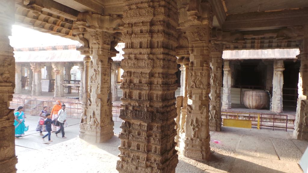
The art of using rock edicts as a medium of communication , evolved in the 2nd Century B.C during the period of Emperor Ashoka of Mayura Empire, for the spread of non violence and spread of Buddhism . This slowly evolved into various types of rock cut architecture , starting from Viharas or place of stay and evolving into various temples formed out of stone, from the late 5th Century A.D. Aihole, in Karnataka, is believed to be the cradle of the Temple Architecture, where the earliest formed temples structures were found
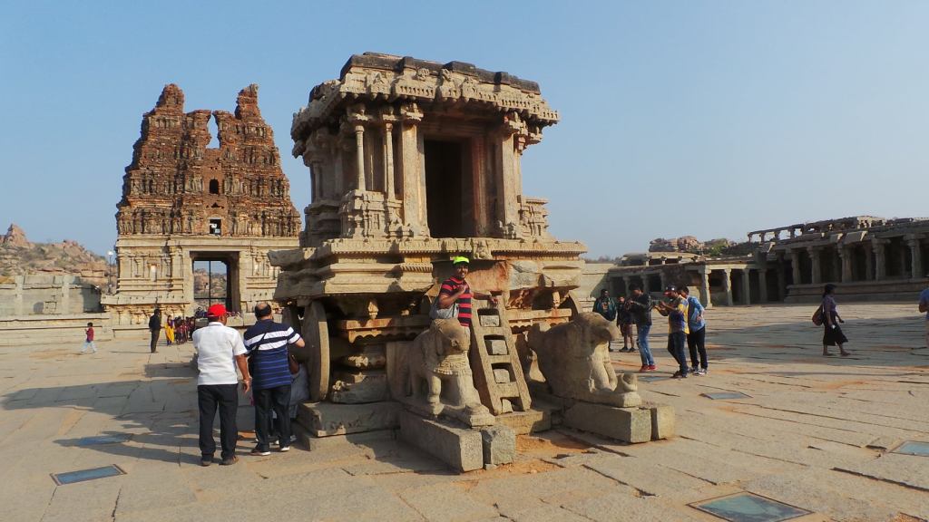
Stone chariot of Vittala Temple
The period of Vijayanagar empire in the later part of 14th Century , was the period when the temple architecture had reached the zenith. Temples had turned from mere places of worship, to a place of showcase the prosperity of the empire and the ruler. Temple construction, had evolved into a separate profession by itself, the various stones being chiseled by the skilled crafts in the hands of the sculptors to evolve into a mighty artistic feature , that showcased the prevailing trade and culture of the religion
Pillared hall of Hazara Rama Temple showing scenes from Ramayana
Vijayanagar Empire, was located in the dry arid region of the Deccan plateau, where the presence of the boulders was abundant. The artistic manner in which the temples have evolved, have given little gap to differentiate where the temple ended and where the nature started. The temples had well blended into the background of the region, showcasing the splendor that the region once held. Till today, the visit to these temples , gives an idea of the richness of the kingdom that once stood in this region
The below are some of the grandeur structures that still dot on to this area:
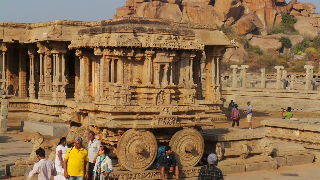
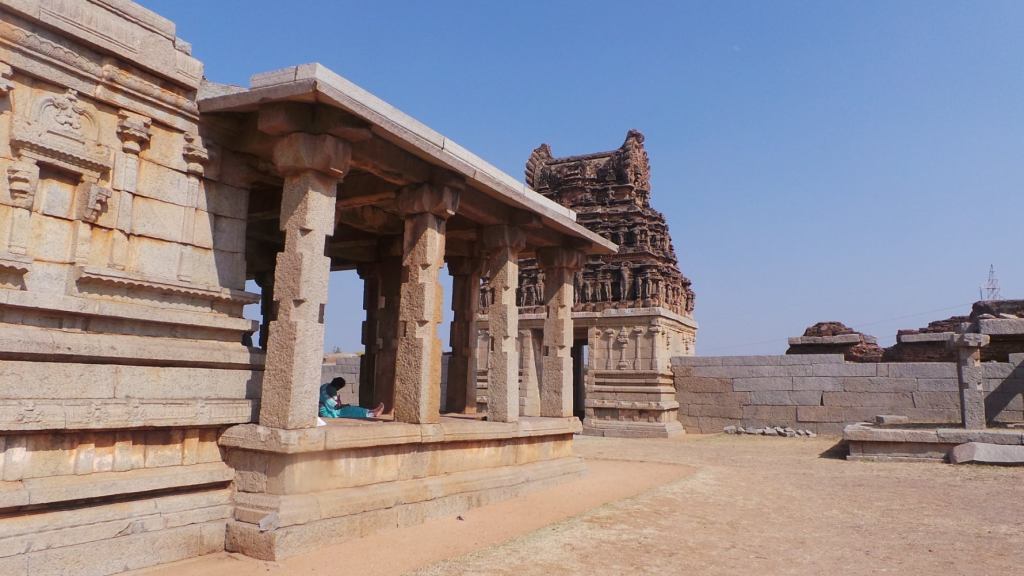
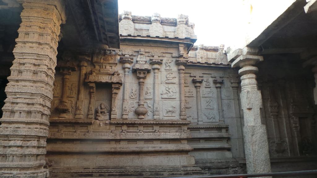
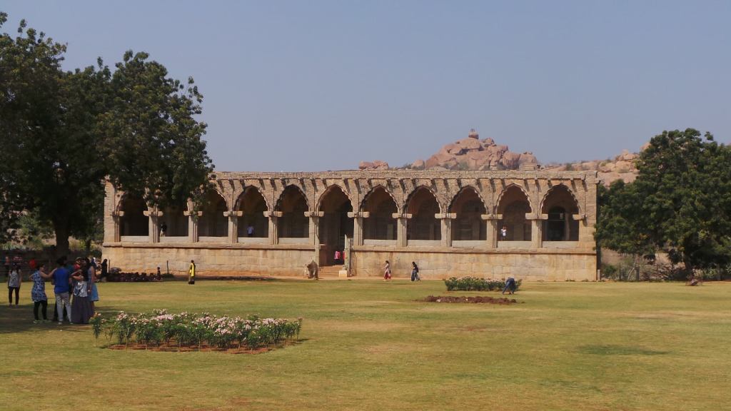
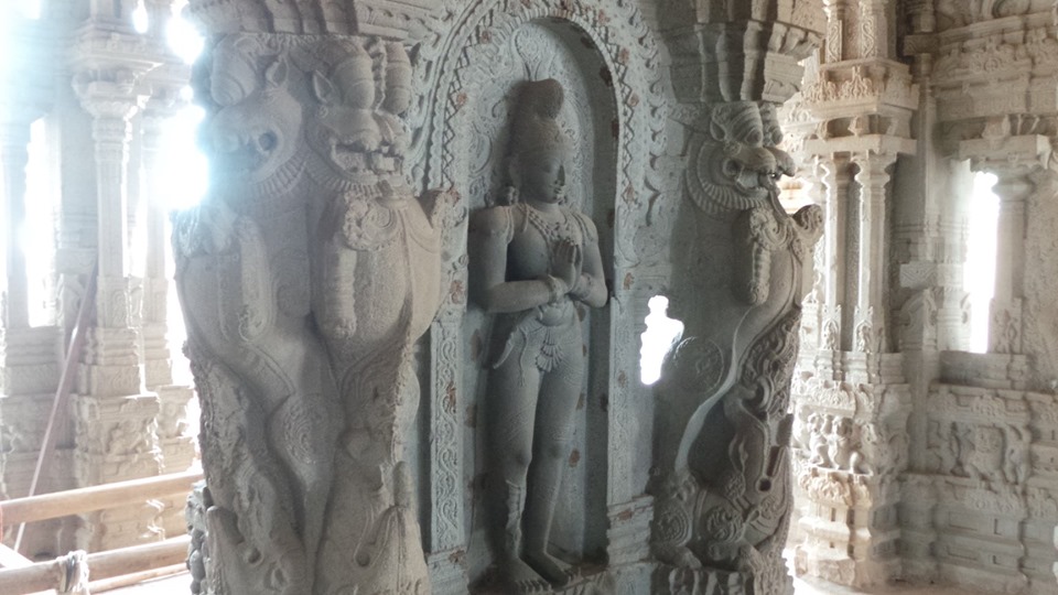
Vijaya Vittala Temple :
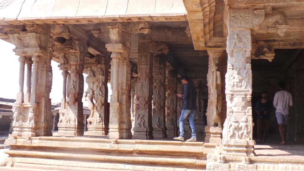
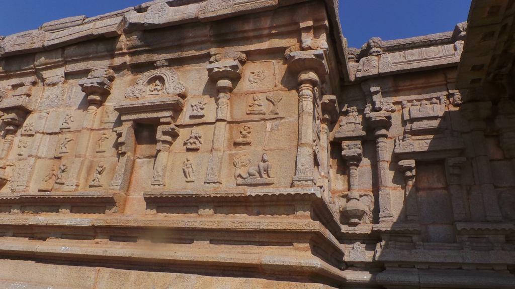
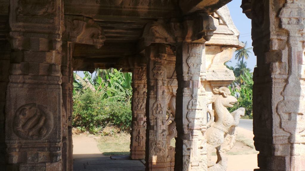
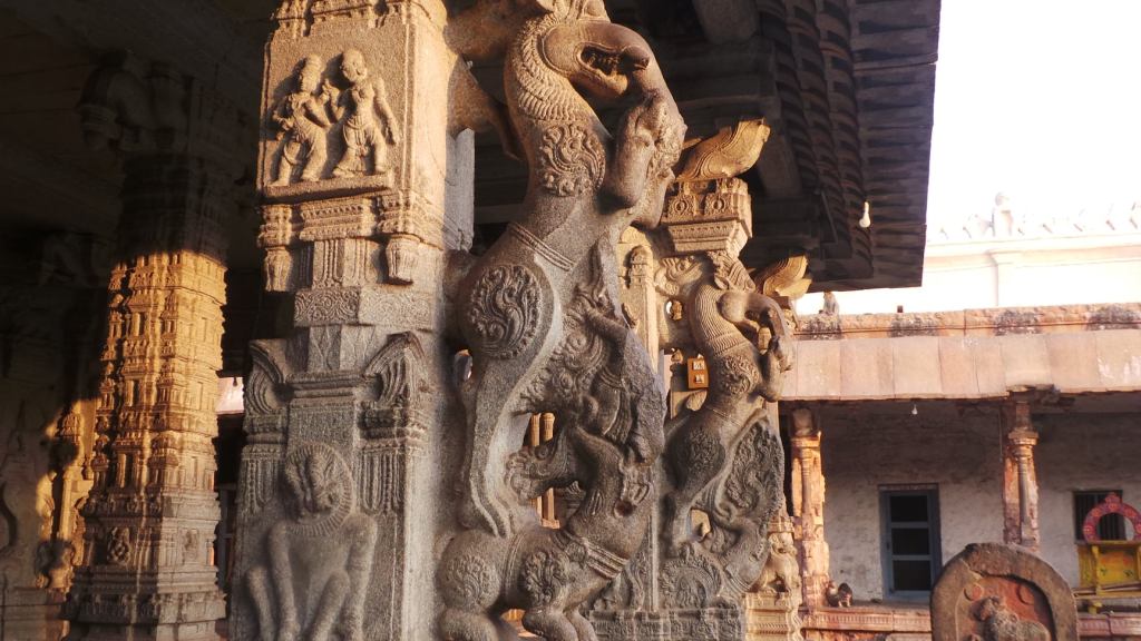
One of the most elaborate structure and the largest temple in this region, this temple is dedicated to Lord Vijaya Vittala, an incarnation of Lord Vishnu. The Temple is most famous for housing the stone chariot near the entrance, with an image of Garuda (Eagle), the vehicle of Lord Vishnu. This Temple, believed to be started during the period of Devaraya-II in early 15th Century, with elaborate additions added to it, during the period of Krishna deva Raya in the 16th Century
The mantapa of Vittala temple, and the slender pillars
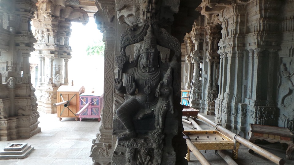
The Temple, has on a sculptured ornate plinth, the composite pillars of the sabha mantapa , which are designed as a clusters of slender pillars, some of them which produce musical notes when tapped gently. The hundred pillared mantapa to the southwest of the temple are carved with various depictions of Lord Vishnu and his other forms and are attributed to the period of Shri Krishna deva Raya . The stone chariot also consists of various paintings, painted close to its celings, using the natural colours available in that period.
The stone chariot and the mantapa
The elaborate structure the temple was planned, looks like was left incomplete, for the entire town was plundered before the complete structure could be completed in the period. However, the completed halls and structures, gives an overall idea of what the structure would have been, had it been completed.
Enroute to the temple, is located the remnants of the old bazzar or market of the temple, the Gejjaala mandapa (A ornate structured hall which is believed to be a dancing hall) and Kudregombe mantapa (The hall of the horse structures)
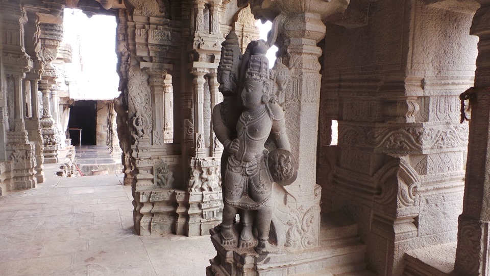
Hazara Rama Temple:
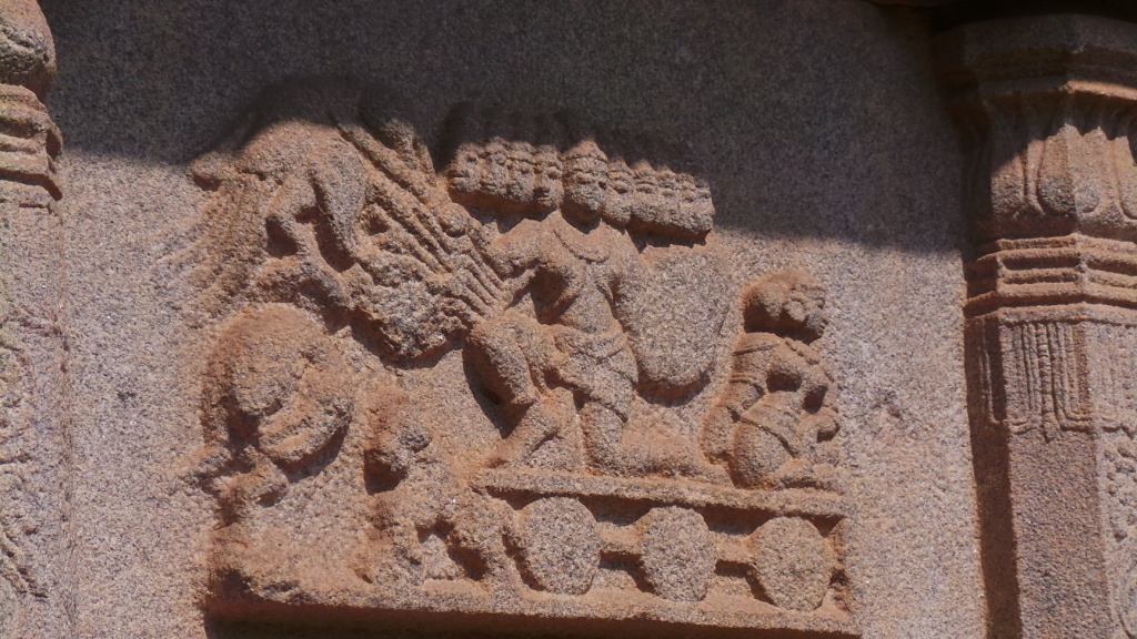
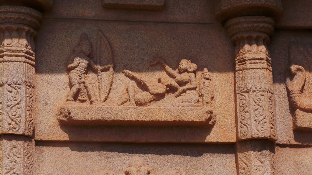
Sculpture of abduction of Sita at Hazara Rama Temple
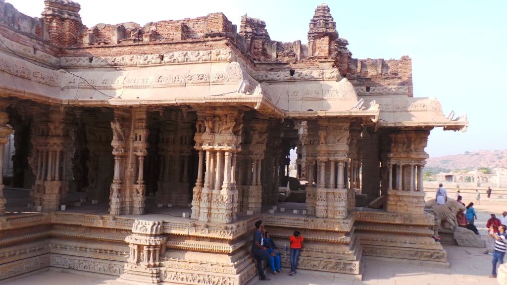
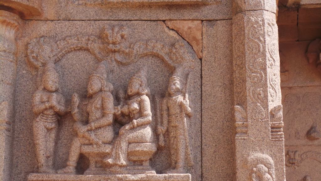
Yet another elaborately structured and completed temple of the Vijayanagar period, this is the only temple located between the residential and the ceremonial enclosures and has is believed to be a temple of Royal patronage. This Temple , dedicated to Lord Rama , an incarnation of Lord Vishnu, if known for its deep friezes, depicting the epic of Ramayana. Various scenes from the epic are described in narrative sculptures, running through the walls of the temples in various tiers and the story of Lava Kusha in the shrine of Devi Sita . The presence of the various sculptures of shri Rama, has given the temple the name of Hazara Rama (Hazara meaning 1000- A huge rounded off number).
The slaying of Vali by Shri Rama as his wife Tara and son Angad look on
This temple, believed to be of the 15th Century period,is a complete structure with a Dravida Vimana, Sanctum, Pillared Dance hall, Pavillion and a separate dedicated shrine for the Goddess. The temple also has various sculptures from Krishna’ s childhood and one of the completed sculptured structure showing the level of architecture that had developed in our country by this period .
Shri Rama, Devi Sita and Lakshmana blessing Guha
Krishna Temple
The walls showing various sculptures of childhood of Shri Krishna
Krishna Deva Raya was one of the famous rulers of the Vijayanagar Empire. During his expedition towards the East, he won over the Kalinga kingdom in the east during the early start of the 16th century . An idol of Balakrishna , was made out of a stone from the Kalinga region and was conscreated at this temple around 1513 AD. The Temple has main shrine , pillared pavilions and halls along with another shrine for the Devi, and also housed a kitchen and a store house. The walls and pillars of the temple houses many sculptures of Lord Vishnu and also episodes from Shri Krishna childhood and scenes from Bhagawat Puran The entrance of the temple opened to a large street with street bazaar and a sacred tank . This temple, being close to the fortified entrance bore the maximum ravage of the plunder, with the main idol of the temple being stolen by the plunderers
Prasanna Virupaksha Temple
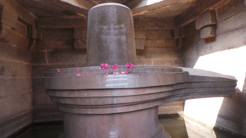
Underground Shiva Temple
One of the oldest temple in the vicinity of Vijayanagar, this temple, is also famous as the underground Shiva Temple, for the current level of the temple is below the road level. The Temple has a Sanctum, aligned with a antarala, Ardhamantapa and Mahamantapa. The temple seems to have been built during the early part of the 14th Century, as the empire was being established, in the honour of Lord Shiva, and the pillars of the temple are completely plain. The temple , also has an inscription of Shri Krishnadeva raya donating the villages of Nagalapura area for the worship of the Lord for the merit of his parents.
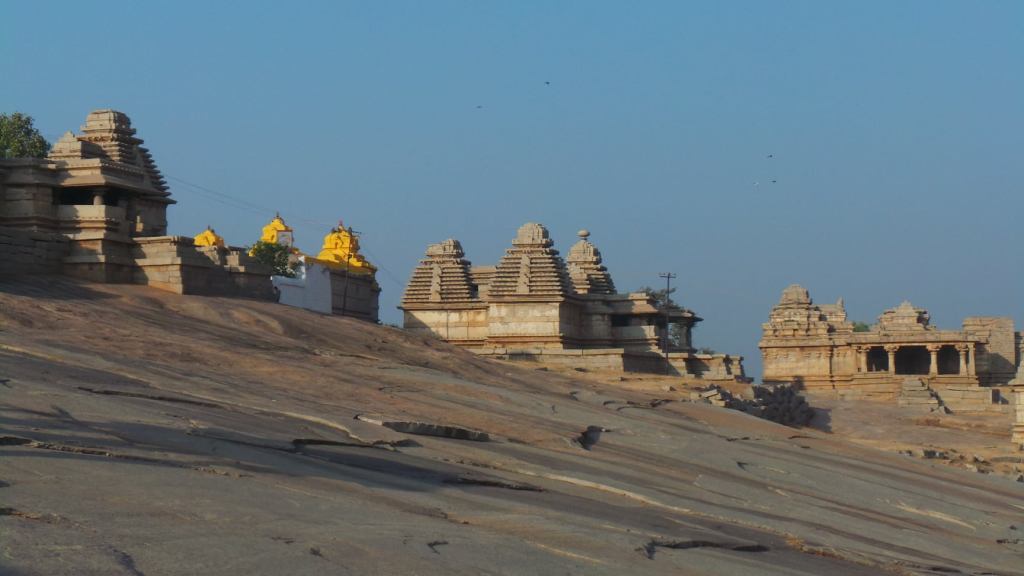
The above Temples, are located within the precincts of the fortified town of Hampi . All the above temples have been taken over by the Archealogical survey of India and no ceremonies are performed at either of these temples. All these temples are open between 9AM and 5PM for public viewing.
The following temples and idols are located just outside the fortified city of Hampi:
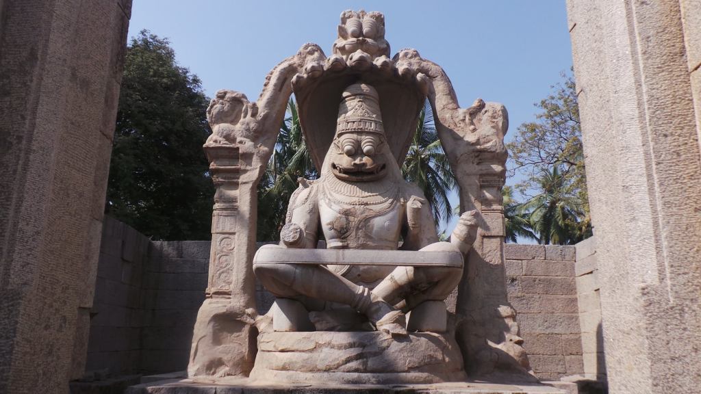
Lakshmi Narasimha statue
Lakshmi Narasimha monolith
Just outside the pernicts of the Fortified town of Hampi, is a monolioth statue of Lord Narasimha, generally confused with Ugra Narasimha. This statue was conscreated in about 1528AD, on the behest of Shri Krishnadeva Raya. The Lord is seated , on a coiled Aadishesha with 7 hoods acting as a canopy ,and is at a height of 6.7 mtrs and is one of the finest example of Vijayanagar sculpture. Lack of a proper roof structure has resulted in wearing down of the structure and the statue of Devi Lakshmi , seated on the lap has gone missing. The face of the Lord has been damaged , which has led people to believe that the statue if of Ugra Narasimha or Narasimha in angry form.
Badavi Linga :
Badavi Linga
Badavi Linga or the Linga by the poor lady , is a 3 metres high Lord Shiva monolith statue which was built by a poor woman and remains in a bed of water . The statue of Badavi Linga is located right next to the statue of Lord Narasimha and is a fairly large pedestal , drawing into a outlet . The Central median eye has the 3-eyed mark.
Chandikeshwara Temple
The front pillared hall of Chandikeshwara Temple
One of the few temples in the region built during the Vijayanagar period, dedicated to Lord Shiva. This Temple is believed to have been constructed in the 16th Century and has a temple plan of a Sanctum, Vestibule, a Mahamantapa and a Mukhamantapa. The pillars of the Mantapa has images of Lions trampling elephants, seemed to have been inspired from the Kalinga style of sculptures. However, the temples has various sculptures carved on the pillars, dedicated to Lord Vishnu and various Vaihnavite representations of Hanuman , Balarama , Yashoda Vamana and various others. The Sanctum has a image of Garuda supposedly facing the Lord, which gives an impression that the temple was originally formed as a Vishnu Temple and later replaced as a Shiva Temple. This Temple, like the above temples, are under the purview of ASI and no ceremonies are conducted
Uddana Virabhadra Temple
Located right opposite to the Chandikeshwara Temple and Consecrated by Dalwayi Jangamayya in the 16th Century is the Uddana Virabhadra temple, dedicated to an incarnation of Lord Shiva. The statue of Virabhadra is almost 16 feet high and one of the largest statue of Virabhadra in the Vijayanagar region . The sculpture holds a well sculptured bow and arrow in upper left & right hand and a bow & shield in the lower left & right hand. This temple is located at the enterance to the town and is the Lord protecting the Town. This temple still has various ceremonies happening.
Saraswati Temple
Saraswati temple
This temple, dedicated to Goddess Saraswati, is located in the middle of a huge barren land in middle of sand and boulders. The temples is completely devastated, but the mukhamantapa holds various well pillared sculptures.
Apart from the above temple, we do have the Virupaksha Temple on banks of Pampa River and the Malyavantha Raghunatha Temple on the Hillock outside the Town, which are also related to the period of Vijayanagar empire, already discussed in the previous parts. Apart from the above, there were various other temples across South India, including the famous Shri Varadaraja Temple in Kanchipuram, SriRanganatha Temple of Srirangam, Devi Meenakshi Temple of Madurai which also underwent various additions and modifications during the period of rule by the Vijayanagar Empire.
The above list completes the places of prominent landmarks in the town of Vijayanagar. Thanks for reading !!!!
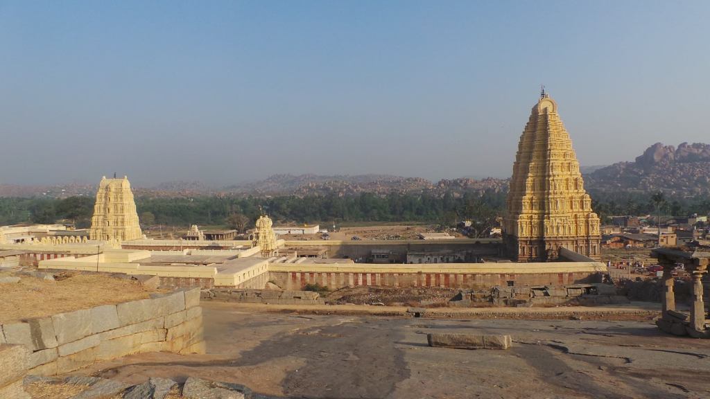
Tungabhadra, was earlier known by the name of Pampa, was also called as Hampa. The village on the Southern bank of the River was named after the river , as Hampi. This Village was pilgrimage centre of Shaivaites, the home to the Lord Virupaksha , an incarnation of Lord Shiva. According to local folklore, Devi Parvati was born as a Girl in the village of Hampi and underwent severe penance to win the hand of Lord Shiva. Lord Shiva, pleased with the penance, incarnated here as Lord Virupaksha and wedded Devi . Devi Parvati is known by the name as Pampa Devi, named after the river banks on which she grew up. Virupaksha Temple, is one of the oldest known Temple in this region, and the village of Hampi served as a Pilgirm centre.
Virupaksha Temple from Hemkunt Hill
The dawn of the 13th Century, witnessed a major turn in the Indian history. The Southern rulers had major in-fights among themselves, and the major dynasties were on a decline. None could claim a massive possessor of any huge land mass. In-fights and incumbent rulers had become too common. The North, then witnessed a change that the Indian region never witnessed before – “The advent of the Sultanate power in Delhi “ with the invaders from the North Western Region
Exterior walls of Virupaksha Temple
The decline of major powers and split up.of territories under administrators proclaiming themselves rulers and the in-fights led to the power moving to the South in the later part of 13th Century . Mohammed- Bin- Tughlaq of the Tughlaq dynasty wanted to shift the capital from Delhi to south, as annexations brought in more territories in the South . But the move did not go on well, and the administrators were appointed in the Devagiri region for taking care of the Southern affairs. The annexation of the South by the Delhi power did not go well with many small rulers, owing to vast plunder and destruction that came along with the annexations, along with imprisonment and loss of independence to freedom of religion.
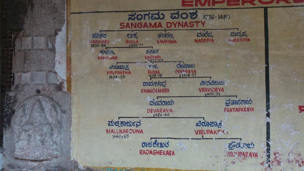
Sangama Dynasty
Harihara & Bukka were 2 brothers, who had been taken captive by the Delhi Sultanate , during the capture of Kampili Kingdom in the South. The brothers, who belonged to the court of Hoysalas earlier, moved to Kampili post the annexation of Hoysala power, but were captured during the capture of Kampili. In a view to subdue the revolt in the South and for appeasement, the brothers, were sent to South as errand by the Sultan to suppress the revolt and to enable the revolting kings join hands with the Delhi power
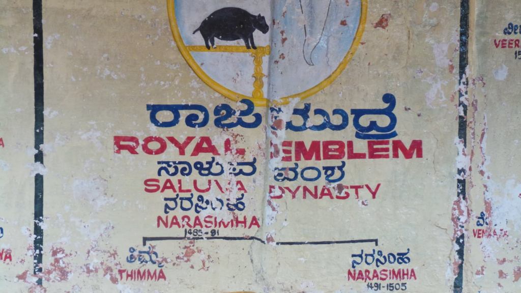
Saluva Dynasty
As per local tales, Harihara and Bukka initially complied with the errand and started gaining the confidence of the people. However, their meeting Sage Vidyaranya gave back their memories of who they actually were and how they were taken as prisoners from Kampili. The sage further, advised them to take the blessings of Shri Virupaksha at Hampi. The brothers visited the temple, and with further realization, shifted back to join the revolting kings , slowly winning their confidence and moving away from the Delhi sultanate. Harihara & bukka initially captured a few territories from control of Delhi powers and started their regime with capital at Gutti (Gooty, Andhra Pradesh) . Harihara coronated himself with the help of Bukka , as the King , at the Virupaksha Temple
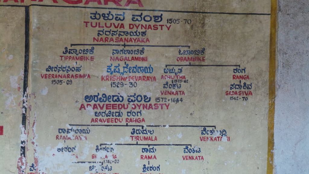
Tuluva & Araveedu dynasty
With further annexations of territories of South and the wealth flowing into the kingdom, they established a City of Victory – Vijayanagar at Hampi, as the capital of the Empire. As a mark of respect to Sage Vidyaranya, a nearby town in the territory was developed as Vidyanagar . This laid the strong foundation of the empire that was set to rule the South for 2 centuries, and a kingdom lineage for 4 centuries, under 4 different dynasties .
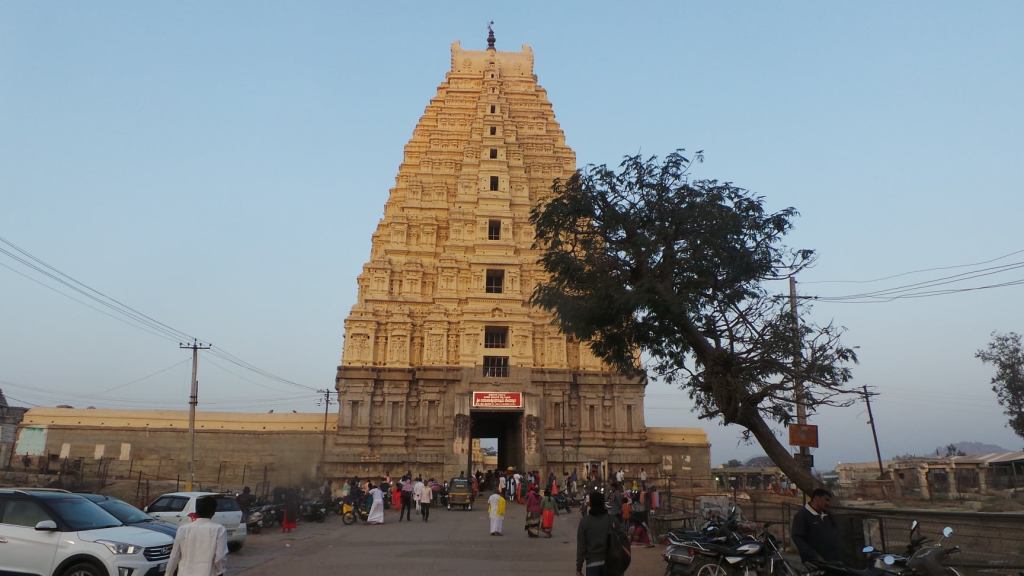
Eastern Gopuram of Virupaksha Temple
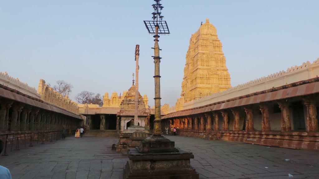
The Temple was of Virupaksha was an original structure built in the 7th Century structure , further on developed by the Vijayanagar empire , during the flourishing times, as the empire progressed. The Temple has a main structure dedicated to Lord Virupaksha and a separate Shrine for Pampa Devi. Both the shrines are well enriched with many sculptures adorning the pillars and the ceiling of the shrines. The Vijayanagar empire contributed to the main hall and the main gopura(Eastern) of the temple during the 14th & 15th century. The main hall of the Temple, has various pillars with sculptures depicting stories of Lord Shiva, his incarnations and the life of his devotees like Bedara Kannappa (Hunter Kannappa/ Kannappa Nayanaar). The main symbol of the Vijayanagar Empire was the Horse with a warrior on his back on a fight (horse with 2 legs in hair) , which can be seen depicted in all the exterior pillars of the main halls. The same sculpture has been spread across various temples in the South, which had been revived and restored under the administration of the Vijayanagar Empire. The Temple also has a Elephant stable near the Goupram of the Temple.
Temple of Virupaksha & Northern Gopuram
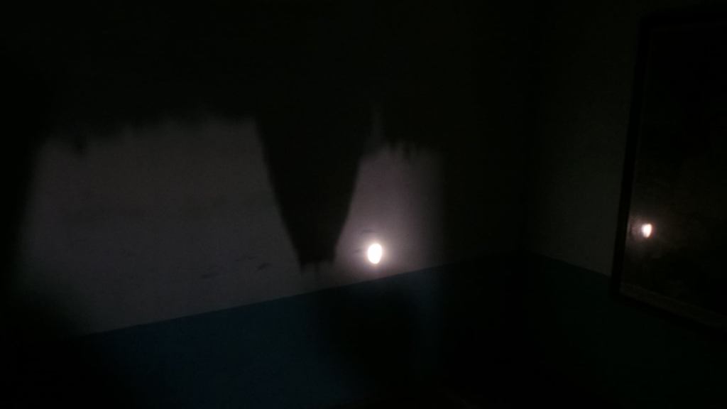
The Gopuram has of the temple has been designed to capture the rays of the early morning sun as it rises from the East. The early morning sun, gives an inverted shadow of the Gopuram on the rearmost wall of the Temple, till the time it moves up above the gopuram .
The inverted shadow of Gopuram in a priest house behind Temple
The main halls of the temple have various paintings and sculptures adorning the ceiling of the temple and the base below the ceiling at the end of the parallelogram. Some of these are relatable to the Vijayanagar period, while some more additions and modifications to the ceiling and ceiling sculptures have been made during the 19th Century . The Northern side gopuram of the temple, which faces towards the bank of the river was also believed to have been built around the 19th century.
Sculpture below the ceiling of main hall
Celing painting
In front of the Eastern Gopuram and right opposite the Temple is the Mathangi Hill, a huge boulder , which is famous for having a sunset view at Hampi . Further down, the street opens out to the street bazaar, a place of commercial exchange, with a lined stone structure finding its place across the corners. These structures for purpose of trade, are found in front of every temple that were constructed during the period of Vijayanagar.
Staircase railing
The Horses welcoming into the hall
The Pillared & Sculpted hall
Right next to the Eastern Gopuram temple, is the Hemkunt hill, homing vertain monuments from the Kadamba era , popularly called the Kadamba group of temples. The opposite descent of the hillock, meeting the state owned road, homes the 2 major Ganesha Statues of monolithic rocks , the Kadlekkalu and the Sasivekaalu Ganesha
Kadamba group of Temples on Hemkunt Hill
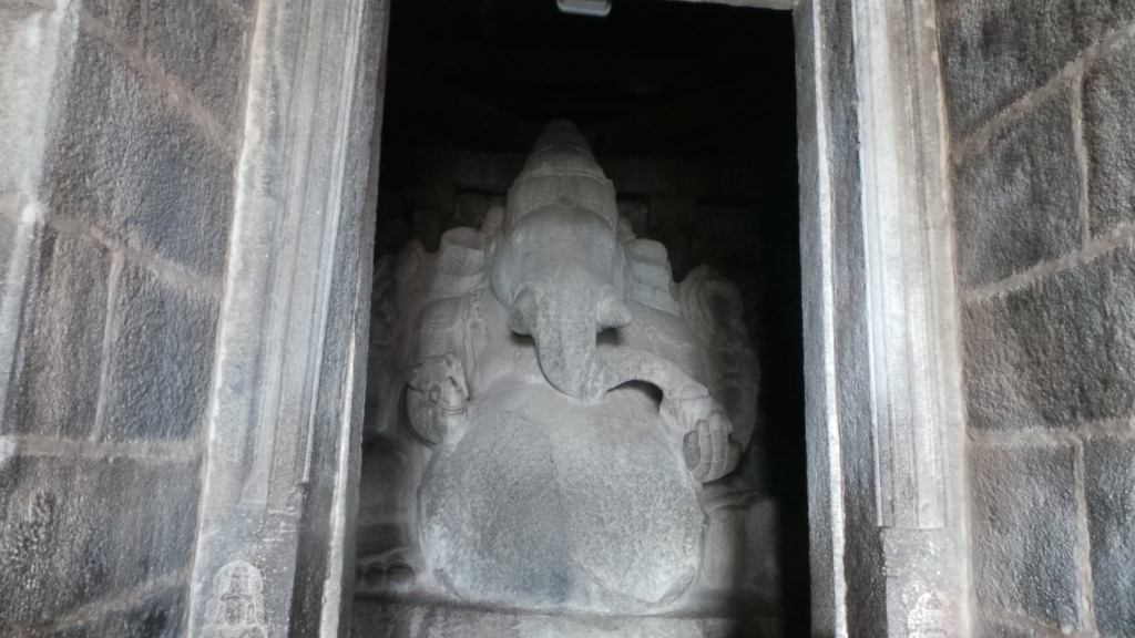
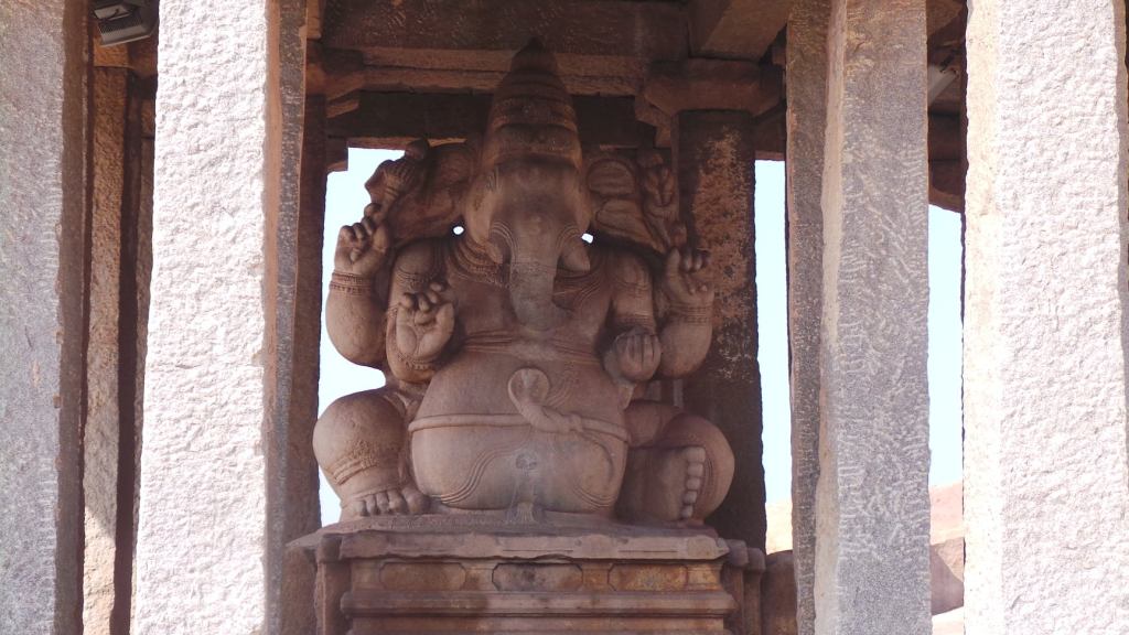
Kadlekaalu Ganesha
Kadalekaalu Ganesha
Kadalekaalu Ganesha is one of the largest statutes of Shri Ganesha in this region, and found towards the other sloping end of the Hemkunt hill. The statue of Shri Ganesha is about 4.8 metres tall and carved out of a single boulder . The statue is placed inside a pillared hall , built around the 16th century in the Vijayanagar period and is adorned with various carvings. The statue is called as Kadalekaalu Ganesha, as the belly of the statue resembles a Kadalekaalu or a bean of Bengal gram .
Sasivekaalu Ganesha
Sasivekaalu Ganesha, is yet another sculpture of Ganesha , with a single tusk, carved out of a single boulder, present towards the ending slope of the Hemkunt hillock , bordered by the road of state government. This statue is about 2.4 metres high and vears a bowl of sweets in his arms and a belt on snake . The status is also present in a pavilion , constructed by a trader in 1506 AD in rememberance of King Narasimha of Saluva Dynasty .
Sasivekaalu Ganesha
Apart from the above , the hill also homes various other abandoned structures which are used as photographic points. The hills also allow a complete view of the town of Hampi and offers some picturesque views of landscape around
Vijayanagar
Vijayanagar, established as a Capital , was a fortified town surrounded by a long running wall across the town. The Town remained the capital , as the lineages ruling the Town kept changing and for a period of close to 200 years, the town developed as a hub for a prosperous trade, keeping invaders at bay. The presence of efficient Kings like Harihara, Bukka and Devaraya from Sangama dynasty, Saluva Thamma & Narasimha from Saluva Dynasty , and the most famous of all, Krishnadeva Raya from the Tuluva dynasty, gave the town and the empire the complete stronghold in the South. However, the prosperity of the town, was a major eyesore for the surrounding Kingdoms , who were earlier under administration of the Delhi Sultanate, but had established themselves as independent kingdoms following collapse of the Delhi Sultanate.
Virupaksha Temple Elephant, Lakshmi
The rule of Krishnadevaraya, one of the most valliant rulers of the empire, from the Tuluva Dynasty , was a major problem for all the major kings, who waited for an opportunity to attack this town, now overflowing with the riches. Changes in the army structure and conspiracies among the teams started post the demise of Krishna Deva Raya in the late 1520’s . This proved to be a major opportunity for the neighboring attackers, who now joined hands to combat a battle against the Kingdom. The battle of Tallikotta in 1565, while the empire was under the Araveedu dynasty, proved to be disastrous to the empire. The Victory of the battle seemed to be in the hands of the Araveedu King , when one of his own armymen, who lured by the attackers, attacked the Ruler beheading him. This created a major confusion among the army men and soldiers and the Towno f Vijayanagar was left unguarded. The Town was plunged and plundered, in what was termed to be as one of the worst havocs of History, the entire town perished under the attack, leaving the prosperous town as a Ghost village.
An old English saying goes “Rome was not built in a day”. So was Vijayanagar, which took years to build and develop, but as they say “destruction is easy, creation is tough”, it was not very tough to destroy the prosperous town, which had devastated the town to anything but shambles. The Capital town was completely shattered, and the succeeding rulers were left with whatever other area was available outside the capital. The rulers tried to safeguard the remaining portions of the empire till the early 18th century , but the prosperous stronghold of the empire was a no match to what it lay to after the 16th century
The destructed structures:
The plundered town still stands tall as a remembrance of the flourishing empire that it was the capital of 4 centuries ago. The town has been considered as a World Heritage Site by the UNESCO , and the ruined structures have been excavated and maintained by the UNESCO with the ASI
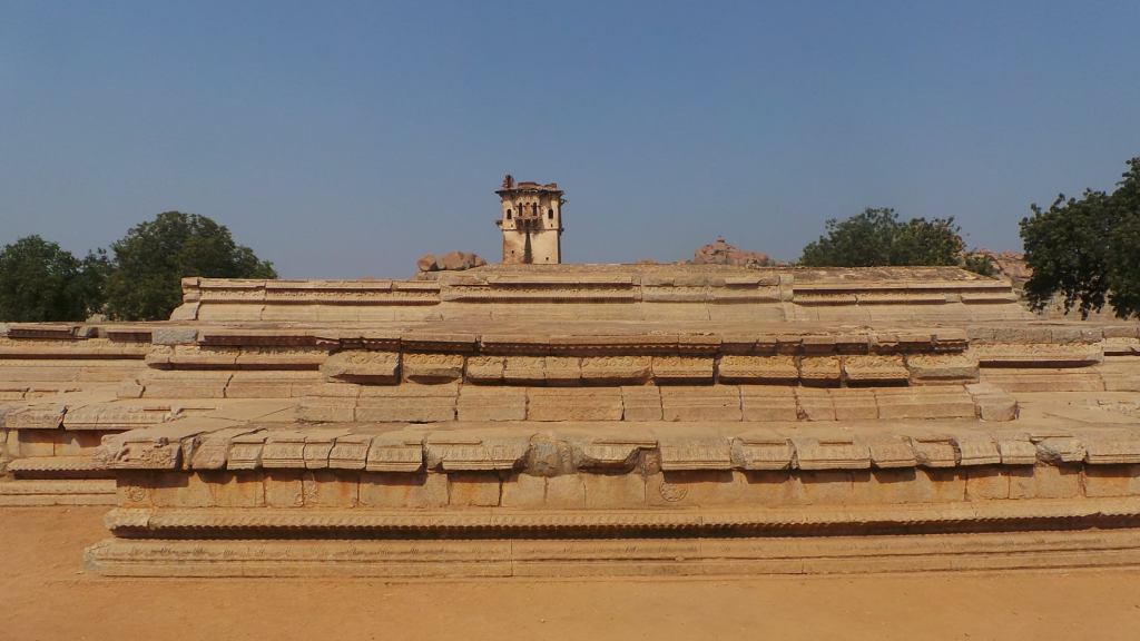
Watch tower strcutre at the entrance of the enclosure
A huge walled structure welcomes us inside the Town of Hampi along a watch tower, the entrance to which reveals nothing but a open ground. The rubbles around the ground, placed symmetrically and systematically across the ground, gives the evidence that this region was a residential area . With a presence of a destructed watch tower at the corner and a plundered band stand in the centre of the ground, the size of the symmetrically arranged rubbles, towering upto 2-3 layers of stone, gives it the basement of a huge palace structure. The recent board kept at the corner gives the name as Vira Harihara Palace, but the way the structure would have been erected and the prosperity it would have lived through leaves one to their own imagination.
Walls of the residential enclosure
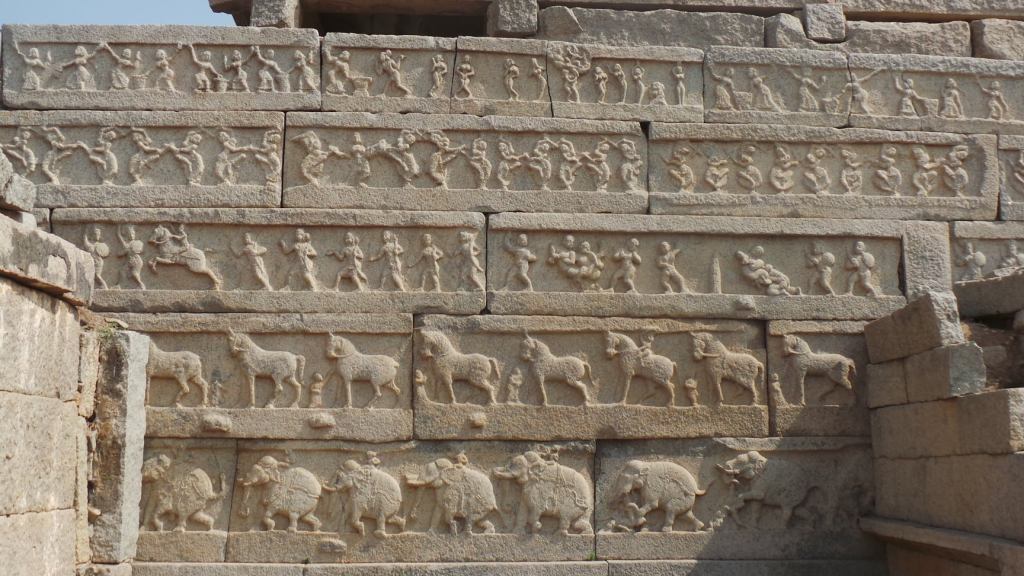
The walled structure that forms the compound of the palace is a 5 levelled stone structure that depicts elephants & mahouts at the lowermost level, horses at the 2nd level, soldiers in the 3rd level, indicating that wars have been a regular feature in this region. The 4th level has various dancers in their posers while the 5th level has people going about their daily routines. The recently erected board also indicates the presence of a mint area in the ground, but it is not clear as to which is the mint area among the rubble
Rubble of Veera Harihara’s Palace
Wall pattern
Another similar wall encounters us, not very far from the above area. However, this walled structure gives the impression of a fort. A walk through this gate brings us to a slightly different sight. The palace is not reduced to mere rubbles , but there is a 3 level stone structure, with a board erected as Queen’s palace basement. There is not much of the structure remaining , but the ruins give an idea of a magnificient palace that could have been here during the period when empire was at supremo . A watch tower at either ends, again in a dipliated condition, indicate the presence of the security in that period.
Queen’s pallace basement and watch tower
A further walk in the corridor, leads us to few structures, depicted in the Indo Islamic style of architecture. These structures, are currently in full structure, also gives an idea how the various forms of architecture would have merged during the period.
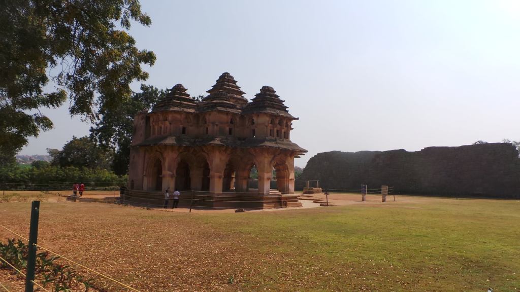
Lotus Mahal
Lotus Mahal- Also known as Kamal Mahal, the Lotus Mahal is a two storied building, built symmetrically in form of a lotus. This building is believed to tbe the place for recreational activities for the Queen and also an area where the Kings could consult his counsel of ministers. The arched domes of the building and the lotus shaped symmetry, allow free passage of air in an otherwise dry , arid region and is believed to have kept the people at comfort from the weather. The walls and pillars of the Lotus mahal and intrinsically carved with birds, animals and various patterns, adorning the structure with a aritistic touch.
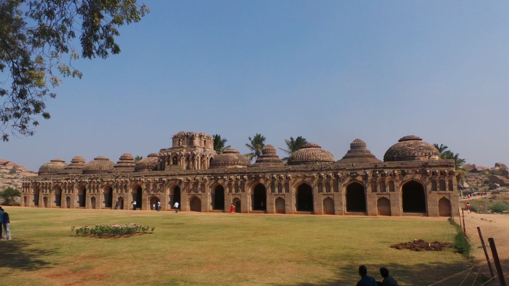
Elephant Stable
Elephant stable – a 11 domed, arched structure, resembling an Indo-islamic structure is believed to have homed the elephants belonging to the ruler. The centre structure of the stable is slightly on a higher dome, indicating it must have been kept for the elephant with the highest honour or the elephant of the King. The complete structure stands still with the time it has been put to disuse, leaving us to our imagination of the period when it would have been in full glory. Access to the tower from the base has been provided by means of a staircase.
Elephant stand
Perpendicular to the elephant stable is yet another 11 dome structure with an elevated platform, along with a passage door, indicating it must have been a place of embarking the huge elephants by the Kings & his ministers, as the elephant are bought out to be taken on the rides.
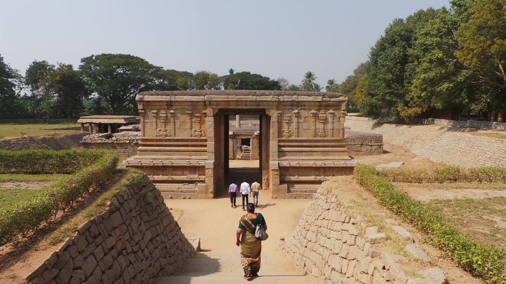
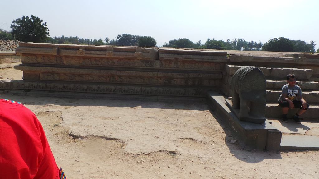
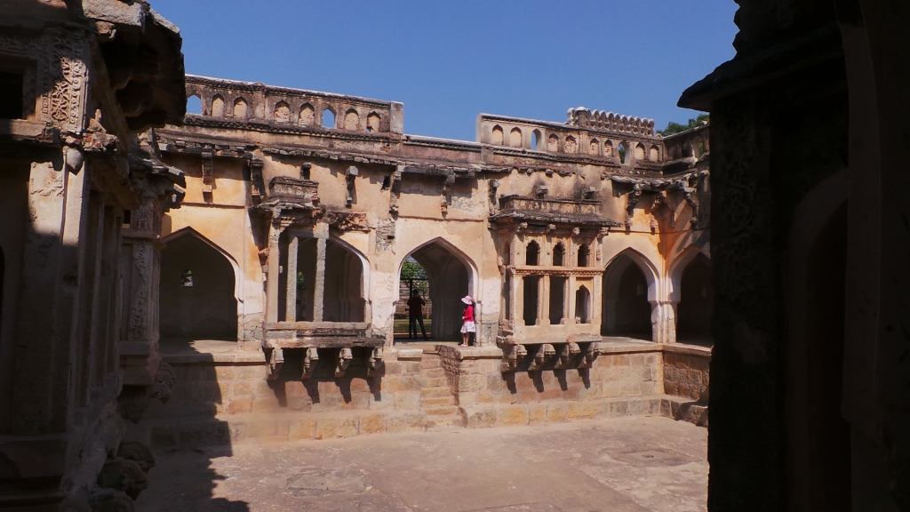
In yet another walled structure,popularly called as Royal enclosure slightly far away from the palaces, but inside the fortified precincts of the town of the Hampi, are various structures on a open ground . the ground seems to be the major area for various ceremonial functions that were held in this Town during the Vijayanagar Empire The area spreads out to almost 50000sq mtrs and is believed to be the nucleus of the Capital City and was protected by double lofty walls. The Royal enclosure is accessible through entrances on 3 sides of the enclosure. Various structures can be seen in the enclosure as under.
Audience Hall
The Audience hall, stands slightly tall among various other structures of the area . The structure is on an elevated platform, and accessible few steps , is in the midst of a huge open ground. This hall is believed to to be the place where the King addressed his audience, but the lack of covering on the structure leaves one to imagination if it was a walled or pillared or an open structure where public could easily see their King.
Secret Tunnel
The Secret Tunnel is a walled structure with access below the ground, with an underground hiding area. The structure seemed to be a hiding structure for the complete people or an escape area in case of an unprecedented attack during the ceremonial functions . The area has been opened up from the top now for easy view by Public
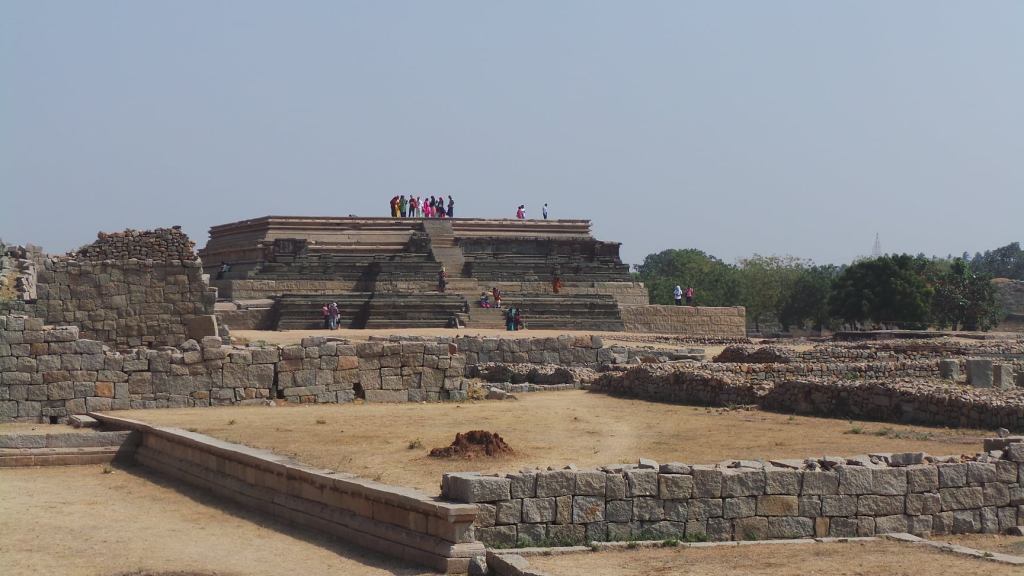
Long shot of the elevated structure of Mahanavami Dibba
Mahanavami Dibba is one of the tallest structures in the ceremonial grounds, rising to almost an height of 8 metres. The structure has been constructed by granite and has been encased in sculptured schist stone. Steep flights of steps on either sides connect to the top. The extant pillar bases in the platform on the top indicate the presence of a pavilion on the top. This structure has been one of the major structures used during major festivals including Mahanavami (Shri Rama Navami or birth of Lord Shri Ram )
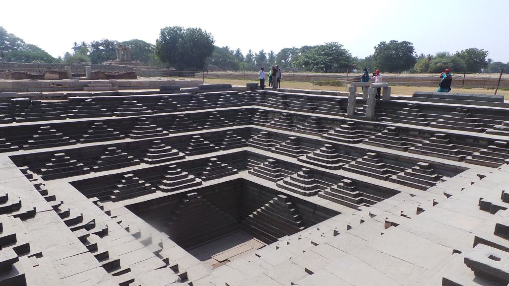
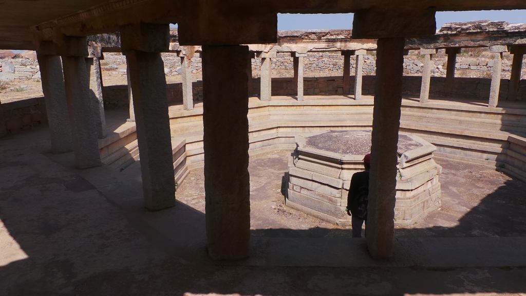
Stepped Tank
Stepped Tank is a beautifully ornamated tank with a flight of steps descending into the tank from the ground level. These tanks are believed to be used for a allowing worshippers and celebrators to have a dip in the water before the start of the related functions. One more similar stepped tank is found near the Shri Krishna Temple of the Town. These tanks were regularly watered with the water from the Tungabhadra river which runs close to the town.
Queen’s bath interiors
Queens bath is yet another structure in the Indo-Islamic architecture at the farther end of the Royal enclosure. The 4 sided structure is dome shaped and has a rectangular area, covered by pipes on all the 4 side and is a completely closed structure. The structure is two-tiered with private rooms on the 1st floor accessible by staircase inside the structure. The various pipes are fed with various ingredients such as natural scents, rose petals, hot water to keep the bath a refreshing affair. River water from Tungabhadra was fed by underground channels to feed this bath
Octagonal Bath
Octagonal Bath is a 8 sided structure , and is also called as Public bath, for travelers from the neighbouring villages or passerby’s to use during the time of festivals or occasions happening in the Town.
While the above form some of the structures found around the town that have survived the devastations, it is not to be forgotten that the Indian Architecture of Temple building had reached its Zenith during the period of Vijayanagar Empire. The various treasures acquired by the Vijayanagar rulers were used for constructing new temples and for renovation and restoration of the previous temples that were victims of various annexations in the South . The City of Vijayanagar , also had its grand share of Temples, which we will see in the next part
India, is a land of wonders. There are various places across the Country, linked through with Mythological events and some which are linked with Historical events. However, there are few places in the country, which are linked with both Mythology and History, seperated by a very thin line, in form of the river One of such places, is in the arid region of Karnataka in the heart of the Deccan Plateau. The Hampi- Kishkintha Region !!!
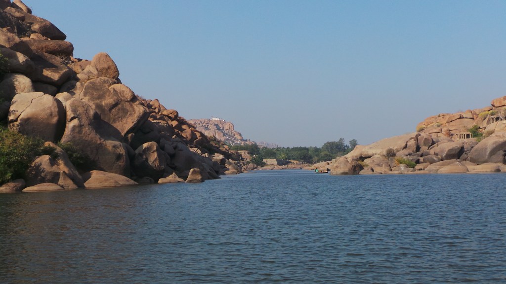
River Tungabhadra at Hampi, ploughing through the Deccan Plateau boulders
Deccan plateau, forming part of the Leeward side of the Western Ghats, is one of the driest region of Karnataka. However, it has a gift for its water needs, in form of the river Tungabhadra. Tunga & Bhadra are rain fed rivers, having their origin in the Chikkamagaluru district of Karnataka in the Western ghats, merge together as Tungabhadra in Shimoga district before proceeding northwards catering to the Davangere , Koppal and Raichur Districts of Karnataka, before merging with the river Krishna in Andhra enroute to the Bay of Bengal. This river, was known by the name of Pampa in the early days, and as a modified form, was also called as Hampa.
It was on the banks of this famous river , that one of the major empires of the South was formed, having its roots in early 13th Century and extending till the arrival of the Europeans in the 17th Century when it slowly vanished, giving its control to the Sultanate . The City, formed on the banks of this river , was the “City of Victory “ established by the brothers Harra and Bukka , who named it as Vijayanagar. The complete city of Vijayanagar, which later became the Capital of the Vijayanagar empires, which extended over 4 dynasties , retaining their hold on complete south, was a flourishing, fortified Town till the time it was captured and annexed by the Sultanate power .
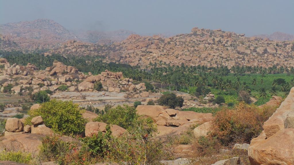
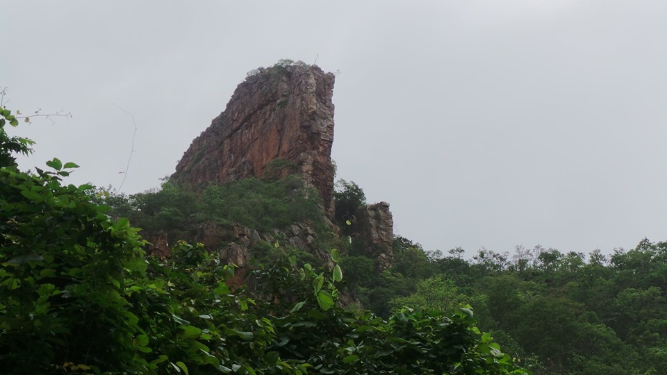
The boulders of the Deccan Plateau
Across the river Tungabhadra on the opposite bank , was another kingdom , which is found in one of the Epics of our Country, “The Ramayana”. This was the capital of the “Vaanara Rajya” ruled by Vaali and later handed over to Sugriva. The boulders and rocks formation which form the ecology of the region , has been explained in the epic as to where the King Vaali, his Brother Sugreeva, Prince Angada and Minister Hanuman had their kingdom of Kishkintha , while Shri Rama and Lakshmana went in search of missing Sita devi,the wife of Shri Rama , who was abducted by Ravana, the demon king of Lanka. The place is currently referred as Anegundi
PART 1- Mythology
Finding a mention in the epic Ramayana, the region of Aanegundi is much older then the Hampi counterpart on the opposite bank of the river. Aanegundi forms a crux of the Deccan plateau, formed millions of years ago through the deposits of the volcanic eruptions that happened in the Western Ghats. The rocks in Anegundi are believed to be one of the oldest formations in the country
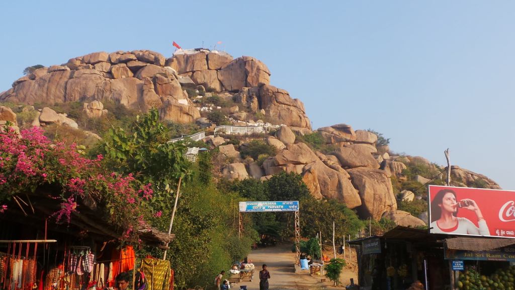
Anjanadri Hill
The Anegundi side of the river is believed to be the place visited by Lord Rama and Lakshmana during his search of Sita Devi, and his meeting with the Vaanara Kings Sugreeva and Minister Hanuman. The following are some of the important places of this region
Anjanaadri Hill
Anjana Devi ,was the wife of Kesari, one of the ministers in the ministry of Vaanara Rajya. Anjana devi underwent penance at the top of this hill towards Lord Shiva, asking for a boon of a Valliant son. Anjana Devi’s prayers were answered by Lord Shiva, through the help of Vaayu, the Wind God, and a son was born to Anjana Devi at the top of the Anjanadri hill, who was named as Hanuman , also known as Anjeneya or the son of Anjana. It is believed that the Anjanadri Hill was the place where Lord Hanuman was born.
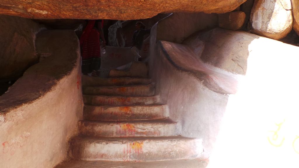
The steps to Anjanadri Temple, cut through the boulder at places
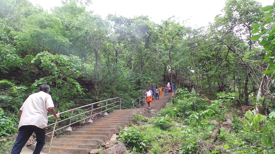
There is a temple dedicated to Lord Hanuman on this hill, along with a statue of Anjana Devi holding an infant Hanuman in her arms. The hill overlooks the Tungabhadra river and the Virupaksha Temple on the other bank of Tungabhadra in the Vijayanagar empire. The Temple can be accessed through a flight of 500 odd steps, and is also a point of sunrise view in this region .
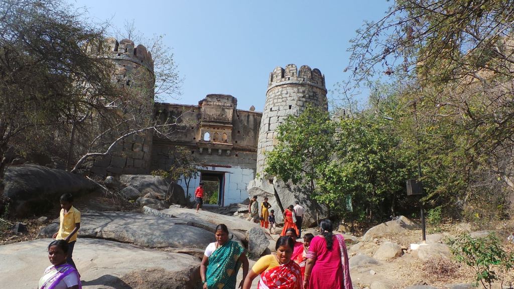
Vaali Gufaa
The Fort structure at Vaali Gufaa
Vaali Gufaa, is a small boulder cave, situated atop a hillock in Anegundi . It is believed to be the cave, or the palace from where Vaali ruled his territory, and after his death, by Sugreeva. This cave, is accessible through a slightly inclined hillock and a walk through a area preserved for medicinal herbs found around in this region. This place is also known as Anegundi Fort, and remains of a Fort can be seen before entering the Vaali cave
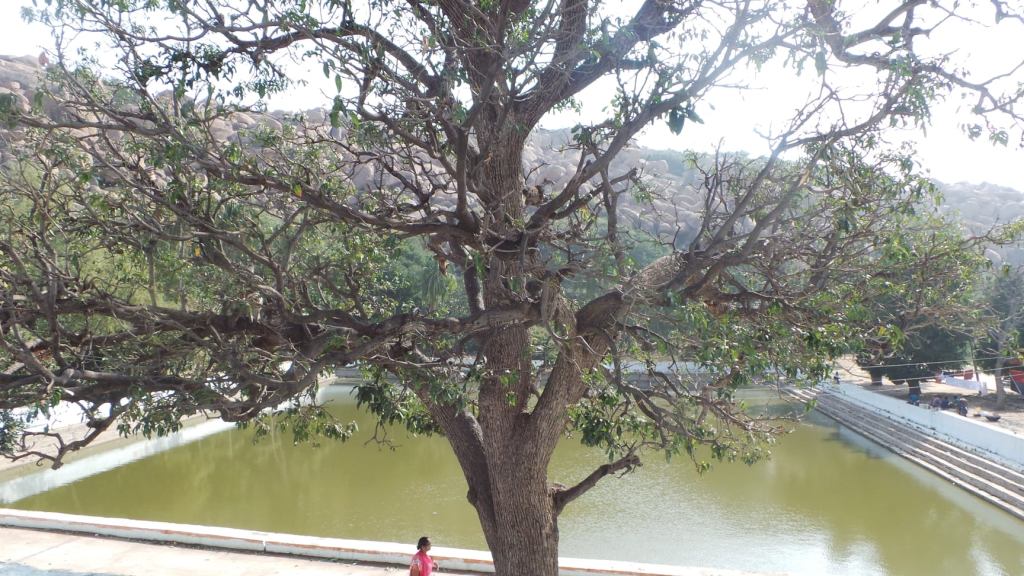
Pampa Sarovara
Pampa Sarovara is a small pond , located about a kilometer from Anjanadri Hill. This pond is supposed to have been fed by the waters of the Tungabhadra. Rishi Matanga Ashram is believed to be on the banks of this Sarovara, where Sabari, disciple of Rishi Matanga spent her days waiting for Shri Rama
Pampa Sarovara
Sabari, a disciple of Rishi Matanga and devotee of Shri Rama, tidied her Aashram everyday, cleared the pathway of all growth and plucked fruits and waited everyday, in anticipation of Shri Rama . To ensure that the fruits were all of not sour, she tasted a bit of the fruit every time to ensure only the best ones are served to Shri Rama. She was completely worried, as she had attained old age, and wished to seek Shri Rama blessings before her end nears
During the search of Sita Devi, who was abducted by Ravana, Shri Rama and Lakshmana wandered through the forest, when he met the injured Jatayu, the King of the birds (Eagle). The injured Jatayu gives them the information of Sita Devi having been taken to Lanka and requests Shri Ram to take help of Sugreeva and team in conquest. Jatayu guides them to Pampa Sarova Ashrama of Rishi Matanga, who can guide them to meet Sugreeva.
As Shri Rama & Lakshmana approach Rishi Matanga Ashram, they are received by Sabari, who treats them with devotion. Shri Rama is impressed by the devotion of Sabari and enjoys the fruits served by Sabari . Sabari in turn, guides them the path to the hill where Sugreeva was present, hiding in a cave after being exiled by Vaali . Lord Rama, in turn, helps Sabari in attaining Moksha.
There are 2 caves in a boulder in this place , one where Sabari is believed to have been in meditation and other where Rishi Matanga was in meditation. These caves are accessible through a short but steep flight of stairs and overlook the Pampa Sarovara.
4.Malyavantha Raghunatha Temple
This Temple, developed during the Vijayanagar Empire, is not exactly in current Anegundi region, but is right opposite to the Anjanadri hill and close to the Hampi Koppal Main road. This Temple, is believed to be the place, where Shri Rama and Lakshamana stayed at Kishkindha.
Malyavantha Raghunatha Temple
In the course of searching Sita Devi, Shri Rama helps Sugreeva regain the kingdom from Vaali, who had sent Sugreeva in exile after a misunderstanding, but had abducted his wife. Shri Rama helped Sugreeva in defeating Vaali, resulting in his death, and handed his Kingdom to Sugreeva and made Angada as crown Prince. Sugreeva, in return agreed to help in finding Sita devi in Lanka and instructed his army men to be sent to all the 4 corners.
Gopurams of Raghunatha Temple carved from boulders
While Shri Hanuman was sent in-charge of the Southern region expedition, Shri Rama hands over his ring to Hanuman, to show it as a mark of identification when he is able to find Sita. It is believed it was at this Temple where the ring was given to Hanuman
This Temple, has been carved out of the boulders in this region, and some portion of the boulders have been left unfinished. The enterance is allowed only through one Gopuram, as the other gopuram is in dipliated condition. Behind this temple,is a series of Shiva Linga and Nandis carved on boulders.
The series of Shiva Linga and Nandi carved
5.Daroji sloth bear sanctuary
During the course of Ramayana , in the ministry of Vaali, was the aged and wise minister of Jambavan, a sloth bear, who with his wisdom, assists Shri Rama in search for Sita devi and also during the course of the final war with Shri Rama. A sloth bear sanctuary is present about 30kms from Kishkindha , indicating the presence of the bears in this region
6.Shri Ranganatha Swamy Temple, Anegundi
Ranghanatha Swamy Temple
One of the ancient temples located in Anegundi side, this temple is dedicated to Lord Ranganatha, reclining on the Aadishesha snake and is one of the famous temples in this region.
As these regions bound on the Northern side of the river, facing the southern side, on the banks of river Tungabhadra and directly seen from the Anjanadri hills, is the temple of Shri Virupaksha. This Temple, which was built during the 7th century, saw major developments during the Vijayanagar Temple. This Temple also formed the epicenter along with the empire of the Vijayanagar was established, the last major empire in the South before the advent of the Europeans , the same which we can see in the succeeding Part linked here
India is a land of diversity. Diversity , exists not only demographically, but also geographically a, historically naturally, mythologically and geologically. The evolution of the Earth over Millions of years has resulted in the current geographical-geological locations. South India, the region below the Vindhyas, is a no-exception to this rule. Bounded on the East and West by the Coasts, the Eastern & Western Ghats forming a border and Deccan plateau lying in the middle, the entire region is diverse.
Western Ghats, the mighty mountains on the Western Side of the Deccan plateau, borders the Arabian Sea Coast .These are believed to be formed during the break-up of the Gondwana Land Millions of years ago. They are the hosts for the monsoon clouds, giving them a good place to stay during their yearly vacation, and in the process, providing the source for the various rivers of Southern India.
The Deccan plateau is the table-top plateau, slightly at an incline. “Deccan” from the Sanskrit word “Dakshin”, converted into “Dakkan” in Marathi and taking a similar form in the English Language. The plateau is said to have been formed as a result of the volcanic eruptions in the Western Ghats, about 65 million years ago. The northern part of the plateau in slightly inclined West towards the Arabian, while the Southern part is inclined East towards the Bay of Bengal. The rivers of the Southern Western Ghats using this incline effect, tend to flow towards the East, cutting across the Deccan plateau, making the region fertile
Eastern Ghats
The Eastern Ghats are majorly the result of the volcanic eruptions from the crust of the Earth millions of years ago, and have a complex geology along the places. They are not a continuous range like the Western Ghats but stand out as hillocks or small hill ranges. The disintegration of the Eastern Ghats is believed to be the effect of the East flowing rivers from Western Ghats, cutting them through at places, as they move to the Sea. Eastern Ghats do not stay close to the coast like the Western, but move inside around the Deccan plateau regions, as they move south. The region of Eastern Ghats is majorly taken into consideration by the geologists, based on the rock formation at various places.
The Eastern Ghats starts its presence in Southern Orissa, moving through Vishakapatnam region of Andhra Pradesh, encircling the Godavari and Krishna rivers, move into west AndhraPradesh towards Tirupati, further into Tamilnadu. The Eastern Ghats and the Western Ghats, meet near the Nilgiris, around the Cauvery river basin on the Tamilnadu, Karnataka border, forming a passage of the forest beings moving from the Eastern to the Western Ghats
In the midst of the Eastern Ghats, lies the lush green forest of Nallamalla, in the State of Andhra Pradesh . Nallamalla forest is the longest uninterrupted forest region of the Eastern Ghats, though many such regions exist in the Wastern Ghats. The forest do not attract much human habitation and are seldom cut across by cultivation. This basically has to do much about the formation of this region. The rocks in this region are basically hard rocks of quartzite, with presence of sandstone at few places. These are non porus rocks, and do not allow the rain water to go underground. Water has to flow over the rocks like streams, till they reach the plains. They join the inflow of the rivers flowing from the west. Human habitation is majorly restricted to tribal or forest dwellers in this region, majorly meat gatherers, hunting on the animals dwelling in this region. “Chenchu” group of tribes, is one of the major tribes of this region.
Lord Narasimha Sculpture at Lower Ahobilam Temple
Narasimha Awatar
Lord Vishnu, the preserver of the creation, undertook 9 different incarnations (Avatars) for the protection of the three Worlds. Among the 9 Avatars, the 4th of them was Narasimha Avatar. While in all the other Avatar’s He had assumed the forms beforehand in presence of all Deities, sages, devotees, the same did not happen in Narasimha Avatar. The Avatar was shown only in the last moment. The Lord was very aggressive. The purpose ended as soon as the Lord showed his presence. No one had predicted the form the Lord will take. The aggression was unlimited. It took a long time before He could be calmed down. And Lord was calmed and the peace was restored in all the 3 Worlds
What exactly happened?? Everyone was bewildered. Garuda (The Eagle) was yet to come out of the Surprise. He was the vehicle (Vahana) of the Lord. But He himself could not understand what had happened. He was with the Lord always, at all times, but seriously He couldn’t believe his non-presence during Narasimha Awatar. He tried recollecting the incidents
Hiranyakashipu, the son of Sage Kashyapa, was ruthless. His elder brother, Hiranyaksha was slayed by the Lord, when he hid Bhoomadevi (The Earth) into the Milky Ocean (Milky way- Galaxy as per the scientific terms). Lord Vishnu had assumed the form of Varaha (Boar) and slayed the demon with his tusks, and lifted Bhoodevi with his snout to place Her in the position. Hiranyakshipu was very angry. He decided, he must not meet an end from Lord Vishnu like his brother. He sought sage Narada’s advice. Narada adviced him to pray to Lord Brahma the creator.
Portrait of Hiranyakashipu vadh at Upper Ahobilam Temple
Hiranyakshipu , underwent severe penance, disturbing the peace of Gods. Lord Indra, the King of the Gods, was scared of this penance. He decided to imprison Hiryankashipu’s wife, Leelavathi, who was pregnant at that time. As Indra tried abducting her, Sage Narada, stops Him, saves Leelavathi and keeps her in his Ashram. The sage , as part of daily routine, narrated stories on Lord Vishnu, during her stay at the Ashram. . Leelavathi, out of tiredness, slept during these proceedings, but the baby in the womb, was accustomed to listening this. Months later, Leelavathi delivers a boy baby in the Ashrama.
As a result of his penance, Lord Brahma came before Hiranyakashipu. Hiranyakashipu requested for boon that he shouldn’t meet death. But Lord Brahma said that is not possible. Hiranyakashipu requests Lord to grant Him a boon that he would not die from any living being created by Lord Brahma. The death should not be inside his house , or outside, in sky or on ground, not by a human, or an animal, not by any weapon, neither during day time nor during night time”
Lord Brahma grants him the boon. Hiranyakashipu is now the most powerful on Earth. His atrocities continue on Earth (Bhooloka), as well as in Netherworld(Paathalaloka) and the Heaven (Swargaloka). He returns home to find his wife missing. Sage Narada in meantime, assures him that his wife is in his Ashram and son is born. Jubilant Hiranyakashipu, names his son Prahlada and takes them back to palace
The World under the atrocities of Hiranyakashipu, hail him as the supremo. Meanwhile Prahlad grows up , but as a devotee of Lord Vishnu. He believes there is no one more Supreme than Lord Vishnu. Hiranyakshipu enrolls him in Paatashaala (School), but he changes the mind of fellow students as well as teachers. Shocked at his son hailing his enemy, Hiranyakashipu sends him to prison, for loneliness will change his mind. But Lord Vishnu protects him from fear, being with his side as his mother. Angered, he orders the boy be killed- orders snake charmers to set snake on him, mahouts to trample him with elephants, throwing him into the sea, and by seating him in the fire. But the boys’ devotion saves him each time- snakes turn into garlands, elephants worship him, the sea king saves him back and the fire moves away from harming. Disgusted , he orders the boy to drink poison. But the poison turns nectar.
Statue of praying Prahlada at Lower Ahobilam Temple
In the end, with a revenge to avenge his enemy, he takes him to the pillared hall of his palace and asks him to show the Lord. Prahlad, undaunted, replies to him that his Lord is everywhere, including a pillar, or a small stick. Angered by his words, Hiranyakshipu raises his mace and tells Prahlad “ Is your Lord in this pillar??”. Prahlad replies “Of course”. Hiranyakshipu says “ Well if so, let me break this. If He comes I will fight Him. If not I will break your head”. Prahlad was undaunted by this. Hiryanyakshipu raises his mace.
Garuda could not recollect event beyond this. What happened after?? All he remembers was Hiranyakashipu lying in a pool of blood, having been slayed. But how?? He had so many boons to protect himself. Where did he go wrong?? How did Lord Vishnu break it out??
Garuda wanted to see the events. He went to the forest (The current region of Nallamalla Forest) and prayed to the Lord. Lord Vishnu arrives and asks Garuda- Garuda you see me everyday but why did you pray for me now? Anything special??. Garuda replied- “Lord, I am not able to understand what happened. How did Narasimha enter. How was he ?? How was Hiranyakashipu killed??. Lord Vishnu smiled – No problem, I will enact it for you in this region itself.
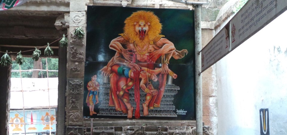
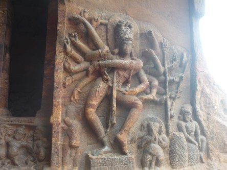
Lord Narasimha catching Hiranyakashipu who tries to escape
The palace was recreated and the scene began to unfold in front of Garuda’s eyes now. The entire mountain was seen as Hiranyakashipu palace. Hiranyakashipu raises his mace, the pillar is broken. Out of it, emerges Lord Vishnu. He is not in his regular form what Garuda has seen. He is half-lion (Simha) and half-human (Nara). There is aggressiveness in the lion’s face and mightiness in the human body. He looks menacingly at Hiranyakashipu. Hiranyakashipu was perplexed. Who is this?? His Guru Shukracharya arrives- He says , He is Lord Vishnu. Pray to Him and ask for forgiveness. Hiranyakashipu refuses. He raises his mace to attack Him. Lord Narasimha chases Him and catches Him. But Wait. He has got boon from Lord Brahma. That cannot become false.
Recalling the boon, Lord Vishnu says – “ I am not created by Brahma- I am neither Human nor Animal- I am “Narasimha”!!!. He points out- Its neither day time nor night, this is dusk!
He drags Hiranyakashipu to the doorstep- “You will not be inside the house or outside, you will be on the doorstep. “ He sits down and places him on the lap- “You will neither be in the earth nor in the sky, you will be on my lap and you will be slayed by no weapon or living being, but by my nails, which have no life”. He tears open the abdomen of Hiranyakashipu, killing Him instantly.
But being in the lion form, Lord’s aggressiveness could not be controlled post slaying Hiranyakshipu . The Gods’ turn to Prahlad for the Help. “Prahlad, the Lord has taken this aggressive form for you- only you will be able to calm him down”- Prahlad sings in Lord’s favour and cool him down. Lord then makes Prahlad the King and teaches him the various philosophies and virtues for a Good ruler and good human
Ahobilam (Singavelkundram, as called in Tamil epics , as the Hillock of Lord Narasimha )
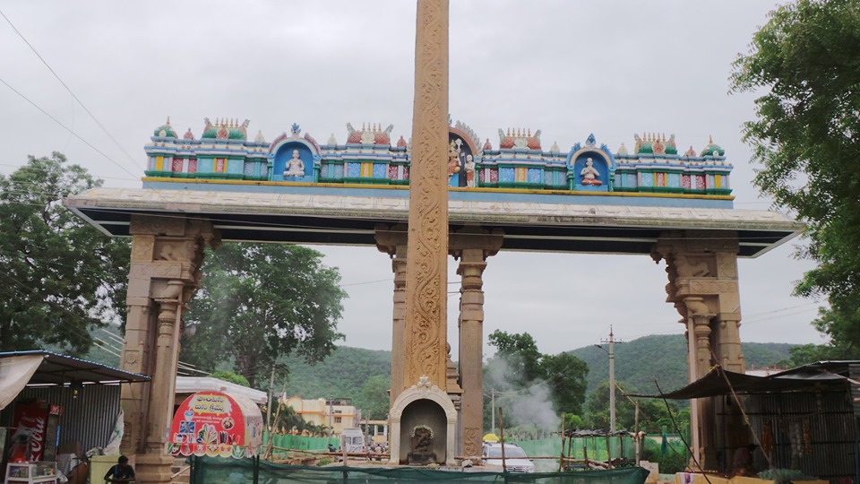
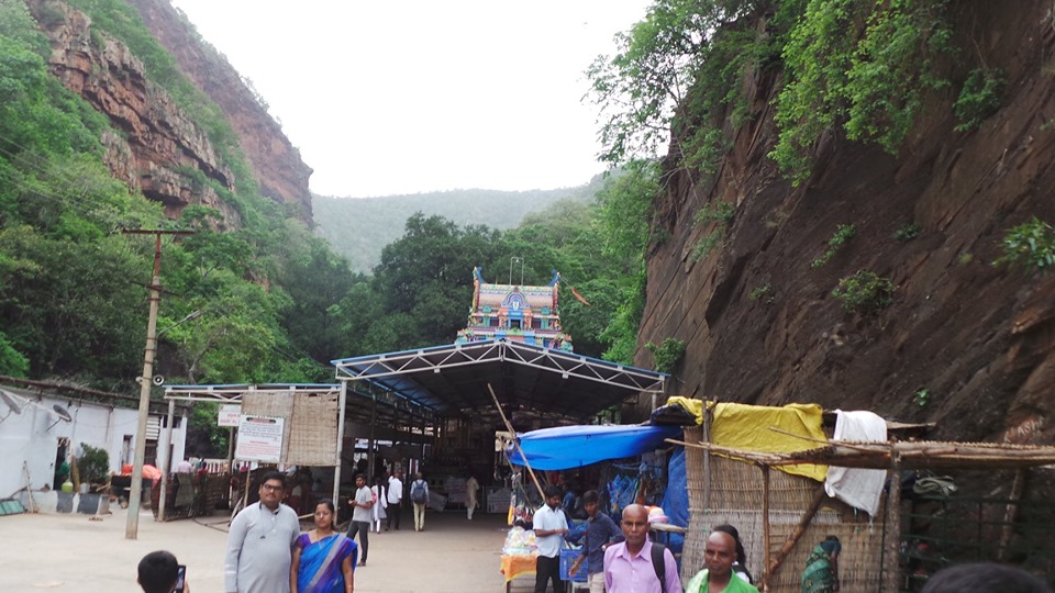
The region where this Avatar was repeated by the Lord, lies in vicinity of the Ahobilam town bordering the Nallamala Forest in Kurnool district of Andhra Pradesh . “Aho” stands for Surprise and “Bilam stands for “cave”. Lord Narasimha, showed the complete avatar in the cave to everyone’s surprise. This Town is situated about 25 kms from Allagadda town, and 240 kms from Hyderabad. Nandyal 70 kms away on the Guntakal- Vijayawada section , is the nearest Railway station to this Town. Allagadda is the nearest bus stand, from where Telugu Velugu buses of APSRTC are available at specific timings
Ugra Stambham or the pillar of anger in Nallamalla forest
Ahobilam Town , is classified into 2 parts, the Lower and the Upper Ahobilam. The Lower Ahobilam is on a plain, about 17 kms from Allagadda town on Kurnool-Cuddapah Highway. APTDC accommodation by Andhra Pradesh tourism Department , along with various other private guest houses available in this here . Food is generally provided through small family run eateries located in this Town. This is the 1st Town after Allagadda while heading to Ahobilam and the last Town bordering the Nallamalla forest.
Upper Ahobilam , houses the Ugra Narasimha Temple at the base, with few “Annadhaana choultires” (Houses providing free food) and very few accommodations. APSRTC buses from Allagadda ply till this temple, located 8 kms away from Lower Ahobilam
The place where this Avatar was re-enacted, are depicted in various temples, in the forests of Nallamalla. The complete forest in Ahobilam is believed to be the palace where the avatar was re-shown to Garuda . The below are the important places in the forest region adjoining the town
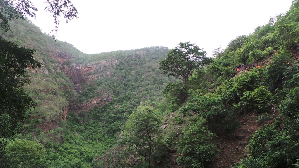
1. Ugra Stambha- The pillar of anger. The pillar from which the Lord emerged. This pillar is on the hill peak in the forest area. The pillar is still said to be hot, out of the anger of the Lord . There is a huge rock protruding out of the Earth at this point. The rock, is a formation of Eastern Ghats and seems to be a result of the volcanic activity .
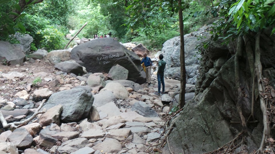
This place can be reached only through trek through deep Nallamalla forest from the Upper Ahobilam Temple, and takes about 5 hrs by walk . Jwala Narasimha Temple is on the way to Ugra Stambha
PS: The walk is through a complete rugged terrain and is recommended for people within the age group of 25- 35 years with a local guide
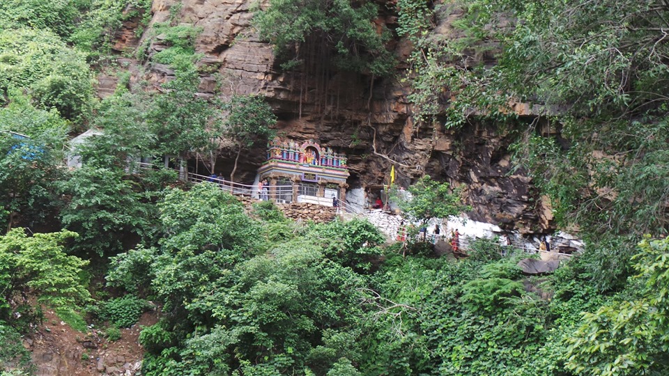
Jwala Narasimha Temple
2. Jwala Narasimha Temple- The Lord is still Aggressive here , the idol inside a natural cave. The idol is naturally formed and is believed to be hot, with the Lord still burning in anger. The idol, a natural formation seems to be a resultant of volcanic activity in this region, likely retaining the heat . Sculptures of Hiranyakashipu, Prahlad, Shukracharya are standing and worshipping the Lord next to him. Lord Narasimha has Hiranyakashipu on the lap at this Temple, in the process of slaying Him. This is believed to be the doorstep of the palace where Hiranyakshipu was slayed .
The walking route to Jwala Narasimha swamy Temple, into Nallamalla Forest
All deities present at time of the slaying of Hiranyakshipu have believed to have recited the Narasimha stotram , to pacify the Lord at this place.
This place can be reached only through trek through Nallamalla Forest from Upper Ahobilam Temple for a distance of 3 kms uphill.(About 2 hrs) Doli services available at cost of Rs. 3000/- per person. Guide recommended for 1st timers at a cost of Rs. 2000/- per person. Support sticks are available for rent at Rs.3/- per stick near the Upper Ahobilam Temple
PS: Panagam (Jaggery water) is provided here by local people, in front of the Temple. Provides a much needed refreshment, once the walk is completed and provides the much needed energy for the return walk
2a. Aakashaganga Falls– A huge stream of water, falls off the rocks, just before the Jwala Narasimha Temple. This is believed to be the water of Ganga, coming down to Earth to cool the Lord. As mentioned earlier, the quartzite rock do not absorb water, but let it flow out, resulting in a waterfall direct to the nallamalla forest. The thick forest do not disclose the area where the water finally lands
The final flight of stairs to Jwala narasimha Temple
2b. Raktha Kundam– A small pool of water, near the temple. The water is slightly red in colour, owing to Lord washing his hands in the same, after slaying the demon. Again, volcanic activity have resulted in different rocks in this region, adding a slight colour to the water
2c. Garudadri hill– The hill on opposite to Jwala Narasimha Temple, in shape of Garuda . Believed to be the place where Lord was worshipped.
3. Kroda Narasimha & Bhoo-Varahaswamy – Normally mentioned as Varaha Narasimha Swamy Temple, the temple has naturally formed idols of Varahaswamy and Narasimha still in anger mode. The sculptures are also inside the cave over which the temple has been built. The main mantapa of the temple is believed to be built in vijayanagar era, with some sculptures around giving the impression
Lakshmi Varahaswamy sculpture at Lower Ahobilam
Unlike avatars of Shri Rama and shri Krishna, where the demon brothers were slayed by the single avatar, the brothers Hiranyaksha and Hiranyakashipu were slayed by Lord in 2 Awatars in this temple. Lord Vishnu is hence seen in both the awatars at this place, indicating the complete story. The idol inside the temple has Bhoodevi on the snout of Varaha
This Temple can be reached through trek from Upper Ahobilam Temple for a distance of 1km.(15 mins) This Temple is on the way to Jwala and Malola Narasimha Temples
3a. Ramanuja Mantapa– A small elevated structure near the Krodha Narasimha swamy Temple, where Shri Ramanujar was said to have performed meditation to Lord Narasimha, during his course of journey across the Country
3b. Dhyana mantapa– A pillared hall, built in the vijayanagar era is situated enroute to the Kroda Narasimha Swamy Temple. This hall is generally used by devotees and sages for meditating , absorbing the calmness of the Nallamalla forest.
4. Mallola Narasimha Temple– Lord Narasimha is called “Maa-Lola” or beloved of the Mother Goddess Lakshmi. Goddess Lakshmi is seen on the lap of Lord Narasimha in this Temple . Post being calmed down by Prahladha, Lord Narasimha gives a darshan to all the deities along with Goddess Lakshmi.
Mallola Narasimha Temple
This Temple can be reached by trek from Upper Ahobilam Temple. This Temple is located at about 1 km from Kroda Narasimha Temple, but on opposite direction to Jwala Narasimha
4a Prahlad Basidior the School of Prahlad is located ½ a kilometer away from this temple, but through a rugged terrain.
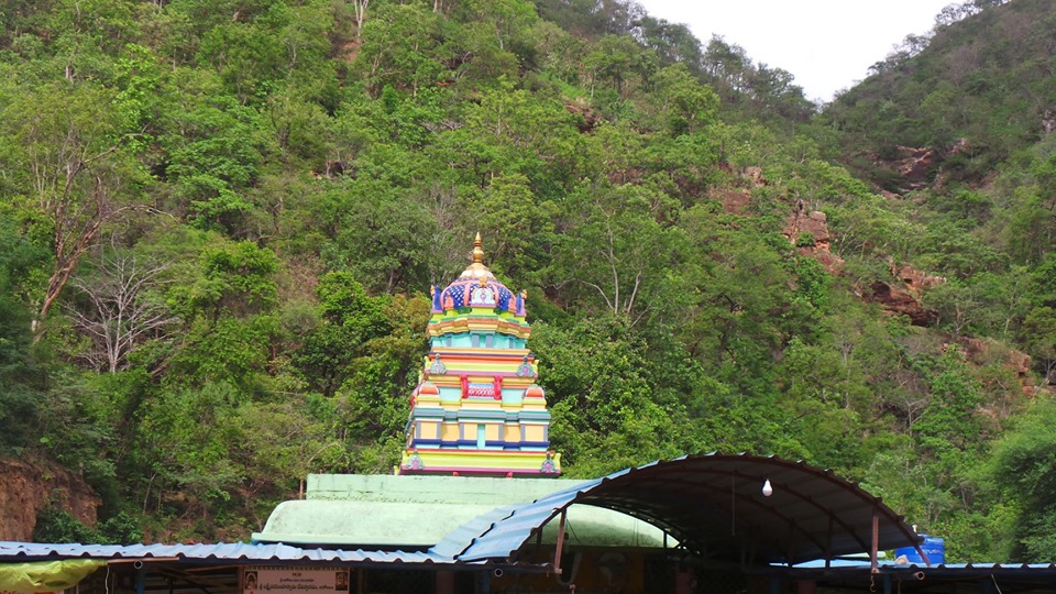
Ugra Narasimha Temple, Upper Ahobilam
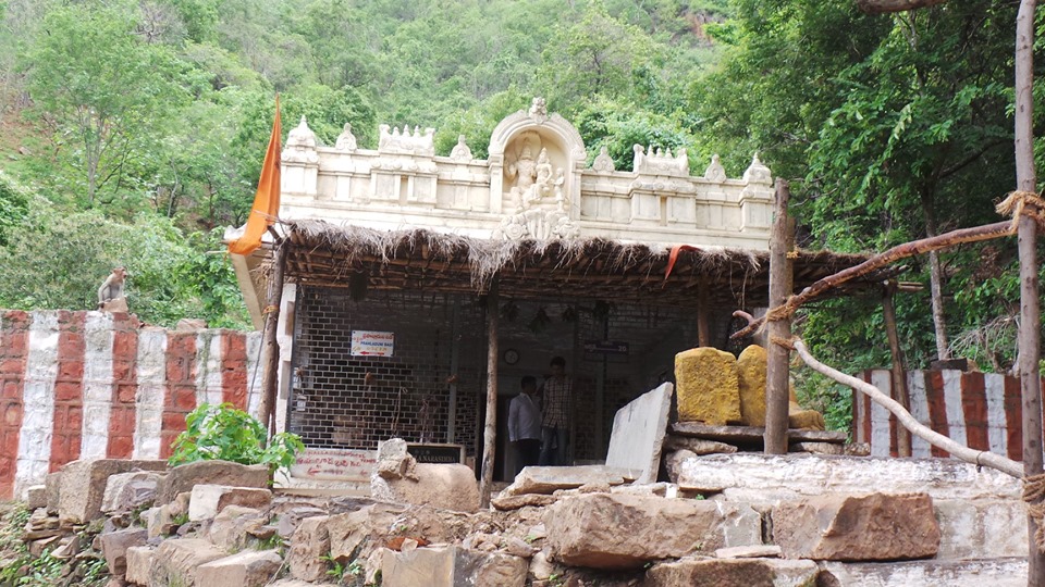
5.Ugra Narasimha Temple- This Temple, forms the base temple at the Town of Ahobilam (Upper). Lord Narasimha is seen in a cave inside this Temple . There is also a statue of Shiva Linga , doing the pooja to pacify the Lord at this Temple. The Lord is still in his angry form at this Temple .
6. Yogananda Narasimha Temple– This Temple is located the town of Ahobilam (Lower). This Temple was where Lord Narasimha preached all the righteousness of a Ruler and a Human Being to Prahlad, after being crowd the King. This Temple also has a small teshrine dedicated to all 9 forms of Lord Narasimha, a summary of all the Temples located at Ahobilam. This Temple is accessible by car and is situated near Lower Ahobilam
While the above places, , form the base of the story of Lord Narasimha , the below places, have their own stories linked to Lord Narasimha of Nallamala forest
1. Karanje Narasimha Temple- Once, Lord Hanuman, undertook severe meditation in Nallamalla forest , in devotion to Lord Rama (It may be noted that the Hanuman birthplace of Kishkintha is located close to Hampi, hardly 200 kms away by road ). But Nallamalla forest was in control of Lord Narasimha, and hence, Lord Vishnu decided to bless his devotee in Narasimha Avatar. Lord hanuman was not happy seeing Narasimha. Lord Hanuman chided Lord Narasimha for coming in such an aggressive form, unlike the peaceful , smiling form of Lord Rama. Hanuman couldn’t accept Lord Rama and Lord Narasimha both were incarnations of Lord Vishnu and are one and the same . To prove Lord Narasimha stood there with the “Shiva Dhanush” bow of Lord Rama and convinced Lord Hanuman. The Temple is situated under “Karanje Tree” and hence, the Lord is named Karanje Narasimha
This Temple is located between Upper and Lower Ahobilam Temple and can be accessed through vehicles
Paavana Narasimha Temple
2. Pavana Narasimha- Lord Narasimha was very aggressive. Everyone was scared of Him, including Gods, Sages and other deities. The “chenchu tribals” of Nallamalla forest were scared to the extent and ran helter-skelter. All , except a beautiful Chenchu lady. Goddess Lakshmi, realizing Lord Vishnu going to Earth, gave her incarnation as a beautiful tribal girl Chenchu Lakshmi , and awaited for God to come down. Chenchu Lakshmi was impressed by beauty of Lord Narasimha, and Lord Narasimha was impressed by the brave girl, who refused to run seeing the Lord. Lord Narasimha took Chenchu Lakshmi as His consort and settled in the forest.
Lord Narasimha, being very fond of Chenchu Lakshmi for having chosen him in this aggressive state, went for hunting and returned with meat for Her. Chenchu Lakshmi was deeply pleased by the care taken by Lord Narasimha
But the tribals felt that the Lord must not be hunting for the meat, just because of marrying a tribeswomen. Hence, they offered to provide meat once a week to Chenchu Lakshmi such that the Lord need not undergo this severe job of hunting . Lord Narasimha , chose Saturday for the same, as it’s a special day for Lord Vishnu . The tribes local tribes still perform animal sacrifices at this Temple, every Saturday as an offering to Chenchu Lakshmi at this stemple
This Temple is located at about 24 kms from Lower Ahobilam temple, but inside the forest. Can be accessed by walk (7 kms- 3 hrs) , or through local jeep rides only(1.25 hrs). This Temple can also be walked from Upper Ahobilam Temple at a distance of 5 kms (Tough terrain).
PS:The jeep ride is not recommended in a post lunch session
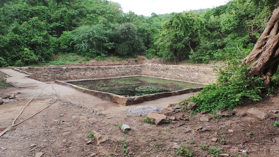
The Tank near Bhargava Narasimha Temple
3. Bhargava Narasimha- Parasurama or Shri Bhargava Rama, underwent penance here, wishing to see their Narasimha Avatar, along with all the 9 awatars of the God. Lord Narasimha, showed his Angry form or Ugra Narasimha here, and the 9 awatars, depicted around on a arch around the idol of Lord Narasimha in the Temple. There is tank at the base of the Temple, constantly fed by stream out of rain water, sprouting under the ground.
This Temple is located about 4 kms from Lower Ahobilam Temple, and can be reached by walk or jeeps. Jeeps charge Rs. 3000/- for covering Bhargava and Pavana Narasimha Temples.
4. Chatravaka Narasimha – While Lord Narasimha was in his anger at Nallamalla, 2 Gandharvas or celestial deities, Aaha & Oho , presiding in the Nallamalla Forest , in a joyous mood , were singing songs in course of their work. Lord Narasimha was moved by the songs , bent down to listen to them. He could not stop tapping his hand , for the song, so He sat down and started tapping for the song on his lap, while the Gandharvas song. The anger slowly turned into a smile. The Lord at this Temple is popular as “Sangeethapriya Narasimha” and one of the few places where Lord is in full smiles
This Temple is located about 1 km from the Lower Ahobilam Temple and can be accessed by car. It is on the way to Yogananda Narasimha Temple.
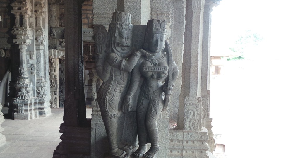
Lord Narasimha and Chenchu Lakshmi sculpted in Lower Ahobilam
5. Ahobilam Narasimha Temple- The Temple at Ahobilam (Lower), which is for the main administration purpose. Lord Narasimha & Chenchu Lakshmi are main deities at this Temple. This Temple is under the administration of Ahobilam Mutt
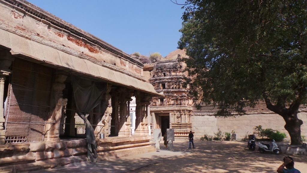
As per History, in the 16th Century, the entire country was majorly under the rule of Non-Hindu rulers. And one of the rulers bought Ahobilam under his siege. The priest residing at this Temple, fearing the destruction, communicated it to the Vijayanagar dynasty. The Vijayanagar ruler, then bought the same under his control and developed the Temple in the Vijayanagar style, safeguarding it completely, and sculpturing it according to Shri Narasimha Mythology. Sculptures of Lord Narasimha, Goddess Chenchu Lakshmi , Shri Varaha Swamy can be seen in the mantapa developed by Vijayanagar Empire. The Temple Gopuram, entrance as well as a pillared hall were constructed around the Temple, during the visit by the Vijayanagar King
Pillared hall near the Lower Ahobilam Temple, constructed during Vijayanagar era
A visit to Ahobilam , is overall , not only for the people undergoing pilgrimage, but for nature, trek, photographic, historic, geographic, geologic enthusiasts as well. A visit to the region gives a much required relaxation from the stress of the everyday run and a much required positive energy to move on in life.
Birds, are the living beings, which can move faster from a place to another, owing to their ability to fly. Thus, from a regular place of stay, they also move to different places to breed. The way they chose their place of stay during migration is a bit astonishing. One such of the place is a small village in Karnataka, located off the main road. Their visit to this place has become to common, that the village itself has been named after the storks
Welcome to Kokkrebellur!! The village of the Painted storks
Kokkre meaning Cranes in Kannada and Bellur signifying the village. The village and the Storks co-existence started in the Mid 90’s period and this village started getting famous as a tourist attraction since then. The Painted Storks and the Pelicans have started visiting this place for the same
Hence, on a fine Sunday morning, post breakfast, we set off to this place, located about 85 kms from the Hustling Bustling City of Bangalore. The 4 lane road to Mysore, with its usual traffic is navigated through, and just as we approach Maddur, a board pops up asking us to deviate from the Main road towards the left
The 4 lane road is left behind, and as we turn left, the scenario changes. A 2 lane, well laid road is for our company for the next 10 kms. Green fields, with crops gives a treat to the eyes away from the concrete jungle. Cattle egrets roam about in the fields, busy with their activities. Bullock carts and tractors with loads of sugarcanes to the nearby sugar mills in Mandya district go past us. No wonder, the Mandya district is known as the sugar belt of Karnataka. Sugarcane cultivation is a major activity in this region, as we run parallel to river Shimsha, a tributary of River Cauvery. Kingfishers and Kites too give us company on the way, diverting our attention.
As we proceed, the paddy thats harvested from fields, is laid across. Driving a vehicle on the roads, post the harvest season, needs a bit of caution. The hay so seperated from such paddy are likely to trouble the car wheels and require regular cleaning. The Government Bus service of Karnataka, connecting a rural area from Maddur, crosses us. Tank embankments border the roads, supplying water of the Shimsha to these crops. The fury of the Mysore Highway is way gone and we are miles into a calmer world
As we near the village, a board is put up welcoming us to the same. The village is busy doing their work and we spot a few birds flying about, looking no larger than crows. The junior storks and pelicans were in the training mode and at that height, look smaller than the crows
We parked the car and walked into the village. The entire village is accustomed to Tourists walking by, that they just give a glance and do their job. The entire habitation consists of 4 cemented roads, dotted by the tamarind trees all around. On these trees are seated, the colonies of Painted Storks, huge in size, busy with their activities all day long. 2 kids from the village, come to guide us. Being a Sunday, school is a holiday and seeing tourists is a source of enjoyment for them, as they move along with enthusiasm
A black Ibis on a tree gives a long view, standing all alone. Looks like its companion has gone somewhere. We find that Painted storks here do not fear a human .After all this is their village. A Painted stork takes a stroll on the road, scaring a chicken that was walking around. A pup, barely able to walk, comes out of a house, only to be scared to wits end as a Painted stork flaps its wings on the tree. The sound is quite huge, thanks to the huge wings of the bird. A Pelican group too are busy in their nests co-existing in the same area
Different colonies of the birds exhibits different stages. A pair was busy in nest building for its offspring, while the next was busy in feeding the chicks. Another colony was busy in the training activities. Training in flight is a very important activity for these birds. Gives a glance as to how well we can understand the breeding season activities of the bird
As we finish a round of the village, we meet a middle aged woman giving us a watch. A round of talk went with her. She said that the birds have been coming to this village for past 15-20 years and the Govt has declared it a conservative zone. Regular training is being given to the villagers as to how to co exist with the birds. Any damage to crops, items or livelihood, caused by these birds is compensated by the Government. The birds, normally arrive here for Sankranti festival (January mid) and leave during the time School starts (June). Even the little boys of the village have taken to birds as their own, having more interest to show them to the tourists instead of attacking them. The various normal birds like crows, kingfishers have left this village ever since Painted storks made their roosting. ” It is their village” the lady says.
“The birds are too strict” she continues. “Whenever any bird is deemed unwell, or a chick falls of from tree or during flight, they get abandoned”. . Then what happens to such birds. “The birds have to be taken by villagers and left in the rehabilitation centre”- she says pointing to the fence at the end of the road. 2 Pelicans sit there quietly suffering from some sickness. Government takes care of those birds, with the help from villagers, till they are healthy to move about and leave the Town.
We look around for some water source but find none. We enquire the lady about the same. “Whatt do these birds do for food”- “They feed on worms in morning, but the leader from each group leave the place in morning returning with huge catches of fish”. they stretch far off into Cauvery and catch them probably or may be even higher reaches of Western Ghats.
So How do the Villagers feel with these birds- Reply- “In initial years we found it very tough as day to day activities were affected- but nowadays we look forward for their visit. Its something like a family member is expected to turn up. We only get tensed if they dont turn up on the allotted day back here”. “The Village, unknown to outside world , has been made known by these birds. So we are happy”
We bid her farewell and continue. “Pat Pat Pat” a bird flaps its wings as its descends on the tree. The Pelicans family is much smaller and easily distinguishable but the net below the throat dangling. Catching fish is easier for them with the net, The birds get set to go about their work, as we get set to move to our next destination for the How to
How to Reach
Kokkrebellur is located about 18 kms from Town of Maddur and 85 kms from Bangalore City and about 75 kms from Mysore.
Maddur is the nearest Railhead connected by trains to Bangalore and Mysore at regular intervals along with trains to Chennai, Hubli and Gulbarga . Maddur is also regularly connected to Bangalore and Mysore with regular KSRTC Express services. From Maddur hiring an auto or cab for round trip is beneficial as bus services to Kokkrebellur are limited and quite crowded.
Driving: As we approach Maddur from Bangalore, about 8 kms before Maddur is the signboard indicating the deviation to Kokkrebellur on the left . The village is located at a distance of about 10 kms from the Highway.
Food and Accommodation
Though the Government has declared it area for Pelican conservation, no other Tourism related works undertaken. options are available in plenty on Bangalore Mysore Highway and its wiser to finish off food before turning into the road
Season
Painted Storks and Pelicans visit this village in Mid January and stay here till June starting. Rest of the time, its a normal village. Temperatures soar high as 35 in March and can reach upto 40 hence advisable to carry caps and water while visiting.
India, is a Peninsula..Surrounded by seas on the 3 sides. The tip of the country Narrows down as we move towards the South, finally ending with a tip at the end. It is at this tip that the seas on the West, East and South of the Country meet. It is at this tip that the land infiltrates into the sea and is known as “Cape”.
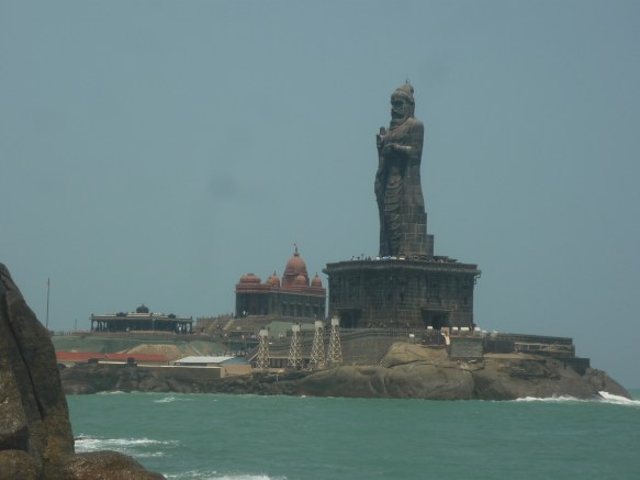
Welcome to Cape Comorin (As named by the Britishers) a.k.a Kanniyakumari (The name its generally knows as in India for all practical uses)
Kanniyakumari- The Land of the Unmarried Lady:
At the confluence of the 3 seas- The Bay of Bengal in the East, the Arabian Ocean in the West and the Indian Ocean from the South is the Town of Kanniyakumari situated. The Bay of Bengal and Arabian sea show their tides supressing the tides of the Indian Ocean which absorbs both the seas into itself and presents a calm smile away from the shore
Legend:
Banasura , a demon, who ruled this region, was ruthless, after receiving a boon from Lord Brahma, that he can be slayed only by an unmarried Woman. Goddess Sakthi, the Universe Creator, was born as a little girl , named Bhagavathy , undertook severe penance to marry Lord Shiva. Lord Shiva assures Devi Bhagavathy to marry her on an auspicious Brahma Muhurtham before the Sunrise on a particular day. In the meantime, the Lord of Devas, Devendra was ousted from Indra Lokha and the Pancha Bhootas (The 5 elements of Air, water, Fire, Earth and Sky) were in chaos without administration
Devas turned to Sage Narada to help them get rid of the chaos. Since Banasura can be slayed only be an unmarried woman, Sage Narada hatches a plan. Disguising as a cock, he crows loudly on the particular day of the marriage, indicating that dawn broke. Lord Shiva return back unable to arrive at the auspicious time enraging Devi Bhagawathy, who takes an oath that she would not marry anyone and would stay unmarried
Days later, while Devi was having a stroll in the garden, The demon Banasura sights upon her and woos her towards marriage. Anger over not able to marry Lord shiva, Devi manifests herself into her true form and slays the demon. Peace is brought out once again in all the Worlds and a Temple for the Goddess was established at this place, naming the Town “Kanniyakumari”
Temple:
The Temple is located close to shore, near the place where the Mukkadal Sangamam, or the confluence of the Seas takes place. The Goddess is known as Devi Bhagawathy amman or Kanniyakumari Bhagawathy Devi.
The Temple is also famous for the Nose stud placed on the idol of the Goddess. Stories are heard of how the Diamond nose stud was very bright, that the entrance of the temple was shifted from the Shore line towards the Town, to prevent the Sailors from reaching the rugged rocky sea shore near the Temple instead of the Port. The brightness of the Nose stud seemed to have lead the Sailors to believe it was the Light House and sail towards the same and hence wall had to be raised on the sea facing side of the Temple.
The Temple is open from 6AM to 11AM and 4PM to 8PM on all days
The Sea:
Surrounded by Sea on the 3 sides, the long coastline helps in enjoying the sea breeze of the evening as we walk around the Town. The Presence of the Sea on both the sides also helps in a proper viewing of the Sunrise as well as the Sunset on the Shores of the Town, making it a unique viewing at different times of the day, subject to cloud movement. Of course, owing to presence of certain High Rises, a small walk across the Shore is required to view them in their respective Eastern and Western Points of the Town
The sand of the Kanniyakumari shore are deposits of the Tides brought in by the 3 seas. Hence the sands depict a different colour as we walk past the shore. As per the Legend, Devi Bhagawathy was angry on the cancellation of the marriage, and in fury, thre away the plates containing the Turmeric (Yellow colour), Kumkum (Orange colour ) and various other items which is said to have added the colour to the place. However, presence of concrete at various places have minimized the differences in colour to actually look into the same
Vivekananda Memorial and Tiruvallur Statue:
Located a bit away from the Mainland, The Vivekananda Memorial was established in 1970 in the memory of Swami Vivekananda, on the rock where He had meditated and attained enlightenment. The memorial consists of a Meditation Hall and can be reached through by boat services operated from the Main land, taking about 20 mins for reaching the same. The Coastline of India, of Kanniyakumari Town is visible from there. The roaring waves of the seas can be heard from the basement meditation hall of the Rock memorial
Tiruvalluvar Statue was established in the year 2000, on a rock in the sea, to commensurate for the works of Poet Tiruvalluvar. This statue, like the Sunrise and Sunset can be viewed from across the Town from terrace. The total height of the statue is about 133 ft.The ferry service to Vivekananda Rock, halts here for tourist viewing of this statue also
The Vivekananda memorial is open for public from 8AM to 4PM. The memorial is illuminated in the evenings which can be seen from the Temple/Sangamam shore
The Temple, the boat ride and Sunrise Point are located very close to the TNSTC bus stand/SETC depot in Kanniyakumari. Sunset Point on the Western side is about 1.5 kms from Ferry Point and Local Autorickshaws available for the same
Suchindram Temple:
Located on Nagercoil Road, about 11 kms from Kanniyakumari, is the town of Suhindram. The Temple is dedicated to Lord Thanumalayar, the incarnation of the Trimoorthy or the Three Gods – Lord Brahma, Lord Shiva and Lord Vishnu in a single form. The temple is famous for innumerous sculptures adorning every pillar and it would require a good amount of time with a Guide to accurately observe each and every sculpture and their speciality and the amount of imagination that has gone into each of them. Musical pillars present inside are one of the main atractions
A single granite statue of Lord Anjeneya, measuring about 22 feet attracts devotees from far and near to the Temple. This statue, forming part of the temple since years, was kept hidden during the invasions under the fear of being stolen or destroyed. The statue, hidden under the ground, was found out about 50 years ago and ever since kept for public viewing.
Suchindram Temple is open generally from 4:30AM to 11:30AM and from 5PM to 8PM. Regular buses plying between Kanniyakumari and Nagercoil/Trivandrum have a stop at Suchindram. The Temple is located just off the Main road and easily walkable
Vattakottai Fort:
Located about 7 kms from the town of Kanniyakumari, was built by the Dutch during the rule of Travancore in the 16th century. Vattakottai, or Circular Fort was built to prevent attack from the sea on either side, as the area was completely sea locked. A small well maintained garden and a series of steps leads into the Fort, which is bounded by the Sea on the side. The fort offers beautiful views of the sea and Western ghats around and Town of Kanniyakumari giving a very picturesque view of the place.
Vattakottai fort is not very well connected by buses. Local autos can be hired to visit the same. The Fort is open for Public from 8AM to 5PM
How to Reach Kanniyakumari:
Kanniyakumari is located in Southern Trip of the Country and NH-7 connects to Kanniyakumari from Varanasi via Hyderabad and Bangalore. Kanniyakumari is connected to Trivandrum Panvel Highway NH-47 from Trivandrum located 70 kms away. Trivandrum is also the nearest airport for CAPE
Trains:
Kanniyakumari Railway station is the nearest station. Kanniyakumari has daily trains from Chennai, Bangalore and Mumbai and Weekly trains to Delhi and Howrah. Nagercoil Junction, located 15 kms away, lies on the Chennai Trivandrum line and is a terminus for daily trains to Bangalore and various other trains connecting to Mangalore and Mumbai via Konkan Railway
Buses:
Regular TNSTC buses connect to Kanniyakumari from Madurai, Tirunelveli and Nagercoil apart from Deluxe buses connecting from Bangalore, Chennai, Pondicherry. Kerala SRTC buses connect Kanniyakumari with Trivandrum at regular intervals.
Accommodation and Food
Accommodation is available in Kanniyakumari with major hotels having terrace viewing points for sunrise ans sunset. Food is available through decent restaurants located through the town.
December 2004: An Earthquake rocked the Sumatra Islands in Bay of Bengal triggering a tsunami across the shores of India. A mass devastation. But in the middle of the devastation of Cuddalore district in South Tamilnadu stood a village, still….. There was a complete protection from the huge waves.. Thanks to Mangroves!
Mangroves: the name immediately brings to our mind the images of the ones at Sunderbans in the East and the home of the Royal Bengal Tiger. But these unknown, small mangrove stretch is present in our own Cuddalore District, attracting tourists and photographic enthusiasts from far and near. Welcome to Pichavaram!!
The Word Mangroves has nothing to do with the king of the fruits- Mangoes though the name might have a similar pronounciation. These are shrubs that grow in the Saline water in dense growth on the various islands present in the backwaters of the estuary meeting the sea. The Vellar Estuary and the Coleroon estuaries in the Bay of bengal forms the base for these Mangroves
As we step into one of the boats operated by the TTDC (Tamilnadu Tourism Corporation) we are greeted by a vast area of emptiness. The estuaries are huge and we feel as if the Mangroves are dotting the edges of the water. The saline water and the humid sun gives a feeling of what we are going to encounter the next 2 hours
As the boat proceeds, we are greeted by the various fisherman boats that dot the area. Known as a fishing village, the estuary provides a major means of livelihood for the fishermen of the area . The fishes give us company alongside the boat as we proceed
As the boat ride ventures further away from the sea shore, almost parallel to the coast and perpendicular to the water flow, we reach close to examining the mangroves in detail. They are a bunch of shrubs collectively staying together. Well -“Unity is Strength “and this togetherness with the deep rooted roots into the saline water is what saved the massive tides from targeting this place
The boatman slowly moves the boat and we venture far away from our point of boarding the boat. The point is lost in sight. The sun is directly overhead at noon. We lose track of directions. The water stands still near the mangroves responding only through ripples of the oar of our boat
We proceed further into the channels formed by the mangroves. This is where major birds too reside as it protects them from predators giving a upper cover. An ocassional kingifhser gives us company flying with the boat rhythm. The shrubs voer us over. The branches that seemed small and thin now touch us with full force giving a small jolt. The roots of the shrubs are dotted with shells. “Crabs stay inside them” says the boatman warning us not to by any chance put the hand in water in these places. “The shells have sharp edges enough to slice your hand” he says. Red crabs move about slowly on the roots in search of their lunch. Reminds us too that lunch time is nearing
The islands are filled with fauna like Fox and crab eating otters. We are prohibited from keeping our legs to descend to the islands lest the shells hurt us or the animals find us or worst we lose ourselves We are asked just to stay still
As we venture through one channel to another, the boatman jokingly asks us to tell the route back. We just smiled. In Tamil movie Idhayakani, the hero is brought blindfolded kidnapped by the villains, and the scene was shot in this area. But why was the hero blinfolded. Even if his eyes would have been open, only the villain could have taken him out from here
In “Thottu Muzhangidum nayanam ketkudhu” song from Chinnavar, the scenes are shown from this particular location, including through one of the small channels. More than the hero heroine, the team should have taken extra care from the hanging branches of the Mangroves while shooting here
As we complete our 2 hour round and return to base, it was amazing how the 2 hours had passed. The boatman also tells about a ride available to the beach at the end of the stuary, but can be undertaken only when the tide is good. Low tide will make it tough to get to the beach and the journey would take 5 hours. “Even in the normal boating, there are about 200+ routes”, says the boatman.. “Well each route would be a different waterscape, thought myself”..We finish our trip exhausted but happy at the peaceful calmness the area provides
Charges:
2-3 boating options available with minimum being an hours ride charging about Rs.100/- a head and the highest being the visit to the beach charging about Rs.600/- including a rest at the beach. Whole day is required for the beach package and hence kindly plan accordingly
Boating starts by about 8:30AM in the morning and ticket issue closes by around 4PM in the evening. Owing to fishing activities and to prevent other issues, night boating is not allowed in the area
Location & How to Reach
Pichavaram Mangroves are located about 7 kms from the town of Chidambaram in Tamilnadu, South India. Chidambaram is the nearest Railhead and a major bus stand for TNSTC buses operated by the State Government
Buses are not regularly available to Pichavaram and hiring a rental cab or auto would be a better choice to reach this place from Chidambaram. Chidambaram is well connected by trains from Chennai Egmore and Trichy on the Mainline and buses from all over Tamilnadu as well as from Bangalore. Chidambaram also has weekly connections with Mumbai (11017/18), Bhubaneshwar (18495/96), Varanasi (15119/20). Mayiladuthurai, located 40 kms from Chidambaram has daily train service to Bangalore, Mysore and Coimbatore
Accommodation and Food
Accommodation facilities are available in the Town of Chidambaram. Food has to be packed at Chidambaram or planned in such a way to finish off or take the same at Chidambaram.
When to visit
Being an estuary with waters from the Bay , water is always present. Best to avoid summer and warm seasons as sitting in the boat will be very tough. Post monsoons is the best season for visiting. Kindly ensure to carry caps and enough liquids as the place will always be humid owing to the presence of the saline water. Carry a pair of binoculars if possible
Sage Agasthya once, after a meal served by 2 brothers , proclaimed “Vathapi Jeerano”.. The demon vathapi, who had posed as a Brother and entered to kill the sage instead was destroyed in the sage’s digesting power. The other brother was killed by the ganga water from the sage’s kamandala
That the sage Agasthya was able to digest the meal, but our eyes dont digest the feast that the architecture of the area provides. It is beyond our digesting capability and need our cameras to chew on the cud based on the camera snaps
Welcome to Badami- Vathapi as per our mythology
Badami, was a capital of the Chalukyan Dynasty who ruled the North Karnataka Part. Like any other dynasties, they were also very fond of Art & Architecture. And the Arch Rivals of the Chalukyas was the Pallavan empire that ruled the Tamilnadu region. The Pallavans too had their own styles of Architecture & Sculpturing
The Chalukyan dynasty, prone to invasions, wanted to establish a Fort in defence at Badami. The region of Badami is surrounded by various Hillocks which had naturally formed small caves in the rocks on the hillocks. The Chalukyas were fascinated by the Rock-cut temples of the Pallava at Mahabalipuram and decided to engrave their fort with similar architecture. Thus was born the Sculptures filled Rock-cut temples of Badami
The Hillock had 4 caves in ascent of the Hill which the Kings wanted to adorn. For the purpose, they chose each of the cave to be dedicated to a particular God, based on the various Gods who were worshipped at that time.
Cave 1: Sculptures dedicated to Lord shiva and various forms
Cave 2: Sculptures dedicated to Lord Vishnu and various forms
Cave 3 : Sculptures related to Jainism
Cave 4: Sculptures dedicated to Buddhism
The caves come in an ascent over the hill, starting with Cave 1 as we enter and ending with cave 5 at the last. A few unused caves too are found on the way, which even today are not very easy to climb and are slippery at places.
A flight of stairs proceed seperately to our right as we proceed which halts at a closed door. The stairs arent a easy climb and the very few steps which are being allowed present a tough climb with a high raise between the stairs. This stairs was perhaps to prevent the enemy from having a very easy access to ascend at the time of war
The structure is not only an architectural marvel, but the basis at which it has been way display the engineering talents too of the workers employed at that time in creation of this place. The rocks have been cut, but delicate working and proper pillar supportings have been provided with the correct stents to ensure that the rocks stay in place and in turn provide a proper look to the structure. To ensure no pillar is plain and boring, each of these pillars support have a seperate arhcitecture as it supports the domes.
As we proceed up the hillock, a pond comes int our view at far below, at the end of which is a small temple dedicdated to Lord Boothnath, an incarnation of Lord Shiva. This was supossed to be place, where Sage Agastya worshipped Lord shiva after slaying the demons of Vaathapi and Ilava.
As per mythology, Vathapi and Ilava were 2 demons who lived in the caves of Vathapi- Badami. They used to disguise as brothers and invite sage passing through the area to a meal. While Ilava used to serve the meal, Vathapu would enter into disguise in the food so consumed by the sages. After food, Ilava used to call on his brother Vathapi, and Vathapi used to come out of sage’s body on hearing brother’s call, in turn killing them. Then both demons used to consume on the humans
One day, as both awaited for their meal, Sage agastya came across to the Town. The demons were overjoyed and did their usual tatics. Just as Sage Agastya finished his feast, he announced “Vathapi Jeerano”. The same moment, Vaathapi drowned inside the feast that was served and was slayed. Ilava, realiisng his brother not respnding to his call , tries to flee but was slayed by the water from the Holy can held by the sage. Later, as a penance for killing, Sage agastya worshipped Lord shiva to free him from the sins and later proceeded on his journey
The Cave Temples are open for visitors from morning 9:30AM to evening 5:30PM and are closed for visitors on tuesdays. The place is undertaken by Archaelogical Survey of India and they charge a nominal fee of Rs.10/- per visitor
Location:
Badami is located in the Bagalkot District of North Karnataka. It is situated at about an distance of 450 km from the State capital City of Bangalore and about 80 kms from Hubli. Strategically located on the Bagalkot-Gadag State highway, the Town is majorly a tourist centre
The Temple of Banashankari, dedicated to Goddess Parvathi is located about 5 kms from this Town
The options for accommodation and food are few. A accommodation cum restaurant is run by KSTDC inside the town offering food and accommodation
How to Reach:
By Train:
Train No. 16535/36 Mysore Solapur Golgumbaz Express connects Badami to Bangalore and Mysore everyday. The train leaves Mysore at 4PM, Bangalore City at 7PM and reach Badami at 6:30AM the next morning. In return direction, the train leaves Badami at 7:00PM and reaches Bangalore at 8AM the next day
By Bus:
Deluxe bus services available from Bangalore to Bagalkot on regular basis. Regular Express buses operated by NWKRTC run from Hubli and Bagalkot to Badami
Best time to visit:
Monsoons and Winters are best time to visit the cave temples. Winters afternoons could be hotter so its better to complete the visit in day time and take rest in afternoons as the area is completely open
When a Temple lies in the valley of the Western Ghats, and a background of green hill surrounds it, it attracts both devotees and tourists alike. An ideal place for pilgrims and trekkers alike, it is famous for seeking relief from the “Sarpa Dosha” . Kumara Parvatha, one of the peaks of the Westrn Ghats, offers one of the most toughest and thrilling treks in the region
Welcome to Kukke Subramanya !!!! Famously known as Subramanya after the Lord of the temple, located on the bank of river Kumaradhara having its origin in Western Ghats
Legend says, that Lord Subramanya (Or Lord Muruga or Karthikeya, son of Lord Shiva and Goddess Parvathi) was filled with anger after the slaying of demon Soorapadhman and sought a place to relax to ease His tension. Hence, the Lord found a place of solitude in the Western Ghats, on the bank of the river Kumaradhara. After washing his weapons in the river, the Lord calmly settled down in the place, now popularly known as Subramanya.
The local villagers who worshipped the Lord , used baskets of flowers for their everyday worship, such baskets locally known as “Kukke”.. Hence the names merged to stand as Kukke Subramanya as its known today.
Legend further states that the King of Birds Garuda underwent a phase of curse and had went on a rampage killing all the snakes He could find. All the snakes were terrified and went into hiding to save their lives. The King of Snakes Vasuki was spotted by Garuda on a fine morning and Garuda went chasing the King. Vasuki enters into a cave but the tail is held by Garuda. Helpless, Vasuki pleads to Sage Agasthya to save Him. Sage Agasthya uses his powers to stop Garuda and instructs Vasuki to the pray to Lord Subramanya, the protector. Vasuki does as instructed and Lord Subramanya cures Garuda of the curse and protects Vasuki. Vasuki in-turn promises the Lord that he will not harm any of his devotees and also that any devotee who prays to the Lord will be cured of all the Snake related “Doshas”
About the Town:
Kukke Subramanya is located in the Western Ghats on the banks of the river Kumaradhara. Devotees have a dip in the Kumaradhara river before visiting the temple.On the way, they visit the Vanadevi amma Temple, dedicated to the Goddess of the region. As they proceed further, they reach the Vasuki Dwara or the Vasuki cave the place where Vasuki escaped from the wrath of the Garuda. The cave houses a small park around and getting into the cave is sometimes slippery Right behind the Subramanya Temple is the Aadhi Subramanya Temple which is suppossedly the olden place of the God. Kumaradhara River also houses a particular variety of fish found in abundance here
Apart from the above, the Town also forms a base fot trekkers to the KumaraParvatha, one of the highest and toughest trekking location in the Western Ghats, filled in abundance with the natural beauty attracting tourists, majorly youngsters.
Located about 15 kms drive from Kumara Parvatha is the Bisle Ghat, yet another spot preferred by nature lovers. the area is filled with scenic beauty and houses a view point from where tourists can enjoy the lush greenery of the Hills around them. On the way to the Bisle Ghat, we cross again the river Kumaradhara running down, unpolluted from the Ghats. The drive is possible only in 4 wheel drive jeeps and not much buses run to this place
Kukke subramanya is located in about 280 kms from Capital City of Bangalore of Karnataka and about 100 kms from the Coastal City of Mangalore at about 180MSL in the lap of the Western Ghats.
The Temple if open for devotees from 6:00AM till 12:30PM and again from 5PM to 8:30PM. Free meals for Lunch and Dinner and provided by the Temple Authorities to the devotees.
Accommodation is available in Temple accommodations as well as private lodges situated around the temple. Accommodation for the Temple Guest Houses can be booked though Bangalore One Offices located in Bangalore
Best Time to visit : Summers could be pretty Hot. Monsoon and Post Monsoon are best times to visit. for trekking enthusiasts, monsoon is best avoided as the trekking spots are abundant with leeches in this season
How to Reach:
By Road: From Bangalore, the route via Hassan is the most preferred and shorter route. Bangalore–>Nelamangla–>Kunigal->Channarayapatna–>Hassan–>Sakleshpur–>Subramanya is the route. The other route could be Bangalore–>Mysore–>Madikeri–>Sullya–>Kukke Subramanya. From Bangalore, the road comes via B.C.Road and Kabakkaputtur to Subramanya.
Regular KSRTC buses available from Bangalore, Mysore ,Dharmastala and Mangalore to Subramanya apart from certain overnight services available from Gokarna, Hubli, Dharwad via Udupi
By Train: 16524/18 Karwar-Kannur Link Express from Bangalore connects to Subramanya Road Station every night, which is located about 15 kms from the Temple. KSRTC buses are available from the Station to the Temple in sync with the train arrival timings.
Apart from this train no. 16515/16 Yeshvantapur Karwar Tri-weekly runs in the day time from Bangalore to Subramanya on Mondays, Wednesdays and Fridays and in return direction on Tuesdays, Thursdays and Saturdays via Arasikere and Hassan